Post-Earthquake Haiti As Seen From Orbit
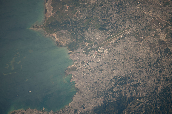
Photographed from the International Space Station orbiting Earth at an altitude of 211 statute miles, this image of the Port-au-Prince area of Haiti from Jan. 22 is centered on the area that was heavily damaged by a magnitude 7.0 earthquake on Jan. 12.
Photographed from the International Space Station orbiting Earth at an altitude of 211 statute miles, this image of the Port-au-Prince area of Haiti from Jan. 22 is centered on the area that was heavily damaged by a magnitude 7.0 earthquake on Jan. 12.
According to the United States Geological Survey (USGS) Earthquake Center, a number of tremors of varying magnitudes up to 6.0 were recorded in ensuing days. Ships can be easily delineated in the harbor. The single runway of the airport, heavily damaged by the quake, is seen near center of the frame. The airport’s control tower was destroyed and has since been rebuilt and is now in service, thanks to part of the huge world-wide aid offered to the nation. high res (2.9 M) low res (90 K)
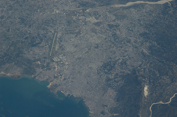
An Expedition 22 crew member onboard the International Space Station took this image of the 260-year-old city Port-au-Prince on Jan. 18, 2010 when they could view the area. This was a few days after the major Haitian earthquake occurred and brought devastation to Port-au-Prince, Carrefour, and the surrounding region. The Toussaint Louverture International Airport, clearly visible on the north side of Port-au-Prince, is the central focal point of incoming international aid. The population of Port-au-Prince is estimated to be between 2.5 to 3 million people. The photo was taken with an 800 mm lens setting. high res (1.1 M) low res (73 K)


