Photo: Tata Sabaya Volcano in Bolivia As Seen From Orbit
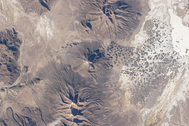
One of the Expedition 35 crew members aboard the Earth-orbiting International Space Station photographed this image of Tata Sabaya Volcano, located in the Altiplano region of Bolivia. The volcano rises to a summit elevation of 5430 meters above sea level. While its current form is that of a “youthful” stratovolcano, the regional geological evidence indicates an older, eventful history, according to scientists.
One of the Expedition 35 crew members aboard the Earth-orbiting International Space Station photographed this image of Tata Sabaya Volcano, located in the Altiplano region of Bolivia. The volcano rises to a summit elevation of 5430 meters above sea level. While its current form is that of a “youthful” stratovolcano, the regional geological evidence indicates an older, eventful history, according to scientists.
The scientists say that prior to approximately 12,000 years ago (during the late Pleistocene Epoch), a large debris avalanche was formed by collapse of the ancestral Tata Sabaya volcano. Debris from the avalanche swept into the nearby Salar de Coipasa –at that time filled with a lake larger than today — significantly changing its northwestern coastline. Timing of the event is obtained from tufa deposits formed on debris islands during a high stand of the Coipasa lake — illustrating the geological principle of cross-cutting relationships, in that the debris avalanche had to have occurred before the tufa deposits were formed in the lake.
The Tata Sabaya stratovolcano is located at image center. Several young lava flows are visible on the northwestern and western flanks of the volcano. Peaks visible to the northeast and southwest appear to be volcanoes as well, but unlike Tata Sabaya there is no record of recent activity from either of them (according to the Smithsonian National Museum of Natural History’s Global Volcanism Program). As the Altiplano became more arid and the Coipasa Lake shrank, much of the hummocky terrain of the debris avalanche became exposed over an area of more than 300 square kilometers.
The hummocky terrain is clearly visible at image right. White salt deposits of the salar surround many of the individual hummocks, making them “islands” once again. ISS035-E-18006 (8 April 2013) – high res (1.2 M) low res (101 K)


