Cassini’s New Map of Enceladus
This image shows an updated map of Saturn’s icy moon Enceladus, generated by the Cassini imaging team. The map incorporates new images taken in 2008, with better image processing techniques. Compared to the previous Enceladus map released in December 2008
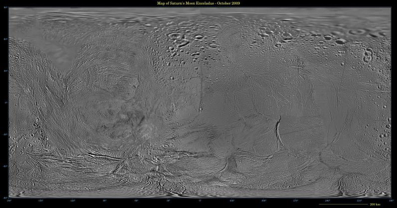
This image shows an updated map of Saturn’s icy moon Enceladus, generated by the Cassini imaging team. The map incorporates new images taken in 2008, with better image processing techniques. Compared to the previous Enceladus map released in December 2008 (see Map of Enceladus – December 2008), the new map features better resolution in several areas, including the equatorial region between 30 degrees north and south latitude and a region between 30 degrees and 150 degrees west longitude. That mosaic and this one were shifted by 3.5 degrees to the west, compared to 2006 versions, to be consistent with the International Astronomical Union longitude definition for Enceladus.
The so-called “tiger stripe” features that have captivated Cassini scientists can be seen distorted by the projection method in the lower middle left and lower middle right of the image. This map contains just one image from NASA’s Voyager spacecraft, which visited Enceladus more than 25 years ago. That image fills in the top left of the map from 90 degrees north down to as low as 50 degrees north in places. Other parts of the map include low-resolution Cassini Imaging Science Subsystem images.
The map is an equidistant (simple cylindrical) projection and has a scale of 110 meters (360 feet) per pixel at the equator. The mean radius of Enceladus used for projection of this map is 252 kilometers (157 miles).
The Cassini-Huygens mission is a cooperative project of NASA, the European Space Agency and the Italian Space Agency. The Jet Propulsion Laboratory, a division of the California Institute of Technology in Pasadena, manages the mission for NASA’s Science Mission Directorate, Washington, D.C. The Cassini orbiter and its two onboard cameras were designed, developed and assembled at JPL. The imaging operations center is based at the Space Science Institute in Boulder, Colo.
For more information about the Cassini-Huygens mission visit http://saturn.jpl.nasa.gov . The Cassini imaging team homepage is at http://ciclops.org . Credit: NASA/JPL/Space Science Institute


