Hurricane Bill Eye Tracked From Orbit

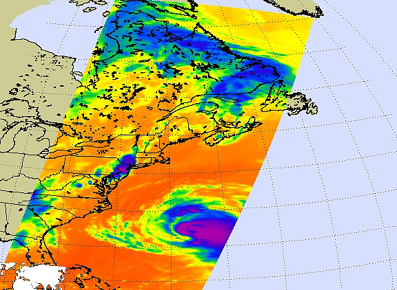
Two perspectives on Hurricane Bill: A vertical profile from CALIPSO is overlaid on an image from MODIS as Bill moved northward on Aug. 19 at about 1:15 p.m. EST. MODIS captures the breadth of Bill and CALIPSO detected the upper portion of the hurricane’s clouds structure. The eye of the storm can be seen as the break in the clouds just south of 19.70 N, about parallel with the southern coast of Cuba. Credit: NASA LARC, Patrick Lynch
Two perspectives on Hurricane Bill: A vertical profile from CALIPSO is overlaid on an image from MODIS as Bill moved northward on Aug. 19 at about 1:15 p.m. EST. MODIS captures the breadth of Bill and CALIPSO detected the upper portion of the hurricane’s clouds structure. The eye of the storm can be seen as the break in the clouds just south of 19.70 N, about parallel with the southern coast of Cuba. Credit: NASA LARC, Patrick Lynch
Residents of Cape Cod, Massachusetts should be making last minute preparations for Hurricane Bill, especially if they live along the beaches, because the hazardous surf will be their biggest concern. Local National Weather Service forecasters are also expecting maximum sustained winds gusting between 30 and 40 knots with higher gusts. Bill will be closest to Cape Cod late tonight (Saturday, August 22) through early tomorrow morning.
A Tropical Storm Warning continues for Woods Hole to Sagamore Beach, Massachusetts, including Cape Cod Bay, Nantucket and Vineyard Sounds, Buzzards Bay as well as the coastal waters east of Cape Cod and south of Nantucket and Martha’s Vineyard. Some strengthening is possible today, followed by weakening tonight and Sunday as the center of bill moves north of the Gulf Stream. Sustained tropical storm-force winds will affect the outer Cape and Nantucket.
NASA’s Aqua and CALIPSO satellites were providing forecasters at the National Hurricane Center with valuable cloud and temperature information on Hurricane Bill, to assist with their forecasts.
NASA’s Atmospheric Infrared Sounder (AIRS) instrument that flies on the Aqua satellite captured Bill’s very cold clouds as he was parallel to North Carolina this morning, August 22 at 2:47 a.m. EDT. The image doesn’t clearly show an eye in the storm, but Bill is still strong Category Two Hurricane with sustained winds near 105 mph.
In infrared imagery, NASA’s false-colored purple clouds are as cold as or colder than 220 Kelvin or minus 63 degrees Fahrenheit (F). The blue colored clouds are about 240 Kelvin, or minus 27F. The colder the clouds are, the higher they are, and the more powerful the thunderstorms are that make up the cyclone. Today’s image of Bill showed high thunderstorms, as cold as -63F!
Where there are no clouds the AIRS instrument reads the infrared signal from the surface of the ocean waters, revealing warmer temperatures in orange and red. In today’s satellite image from AIRS, the surrounding ocean waters were a deep orange, indicating sea surface temperatures of 80F or higher, which is necessary to help a hurricane maintain strength.
Another image on Aqua also captured Bill. The Moderate Resolution Imaging Spectroradiometer (MODIS) instrument on NASA’s Aqua satellite captured the breadth of Bill’s clouds. Bill’s tropical storm force winds extended more than 230 miles from his center today, and his cloud cover was even further.
This infrared satellite image shows Bill’s clouds (depicted in purple and blue) on August 22 at 2:47 a.m. EDT indicating high, cold powerful thunderstorms. The image doesn’t clearly show an eye in the storm, but Bill is still strong Category Two Hurricane with sustained winds near 105 mph. Credit: NASA JPL, Ed Olsen
In addition to the Aqua satellite, NASA’s Cloud-Aerosol Lidar and Infrared Pathfinder Satellite (CALIPSO) captured a vertical profile of the upper portion of the hurricane’s clouds structure. In an image taken on August 19, the eye of the storm was evident in the image taken by CALIPSO as it appeared as a break in the clouds just south of 19.70 N, about parallel with the southern coast of Cuba.
At 8 a.m. EDT, Bill’s center was about 510 miles south of Nantucket, Massachusetts. Relative to the Mid-Atlantic and Bermuda, Bill was almost parallel to Cape Hatteras, North Carolina at 410 miles the Hatteras’ east. Bill had already passed Bermuda, too. Bill was 235 miles west-northwest of Bermuda. He was near 34.0 North and 68.4 west, moving north at 22 mph. Bill’s maximum sustained winds were near 105 mph and pressure was 960 millibars.
High and dangerous ocean swells and rip currents from Bermuda up the U.S. East coast are forecast today, Saturday, August 22, and tomorrow, Sunday, August 23. The Bermuda Weather Service said storm tide will raise water levels by as much as 3 feet above ground level along the coast along with large and dangerous battering waves.
Meanwhile, the southeast coast of the U.S. is already experiencing large swells, high waves, and rip currents. These conditions will continue to spread north along the U.S. coast and into the Canadian Maritimes today and tomorrow as Bill continues his northward track. These are extremely dangerous surf conditions and rip currents. Beachgoers and boaters are urged to not venture out to beaches or the eastern Atlantic this weekend.
Watches and warnings will likely be posted later for Nova Scotia, Canada and Newfoundland.
Text credit: Rob Gutro/NASA’s Goddard Space Flight Center


