Attention NASA Earth Science: Can You Help These Folks?

![]() Editor’s note: This email was sent to us at SpaceRef.com. I thought that the folks at NASA’s Earth Science division might be able to help:
Editor’s note: This email was sent to us at SpaceRef.com. I thought that the folks at NASA’s Earth Science division might be able to help:
“Good afternoon, I’m not sure if ‘suggest a story’ is the right heading, but here goes anyway. I live on Kangaroo Island, South Australia, and found your site while trying to find recent pictures of our Island from space, on the net. You had a pic from several days ago on your website, showing smoke from the wildfires which have now burnt-out one fifth of the Island.
Most of theses fires have destroyed conservation parks, and probably incinerated thousands of our native animals, plus burnt onto several farms, killed about 800 sheep, and taken the precious life of one of our young local men. About 700 firefighters from around Australia and a number of water bombers were sent to fire the fires, which are now said to be ‘contained’.”
“Firstly I am wondering if you have any updated pictures which will show the full extent of Island which has been burnt out, that I could access?
I’m also wondering if there is any way any of your pictures may show where back-burning has been done to try to stop the fires? Of course in the finish the fires burnt into one another, so the latest pics would possibly just show the blackened areas without being able to distinguish between wildfire and back-burn areas. However if they can distinguish the residents over here would be like to see those photos if possible.
Many of the local residents are very angry about these fires. We have been saying for years that because of the power of the conservation lobby and the rules made preventing controlled burning and clearing to keep the Island safe, the Island itself and it’s population of people, animals and biodiversity was being put at ever increasing risk. However the powers that be were not interested in listening.
Even when the fires started they did not want to bulldoze firebreaks or to back-burn, as it would destroy native vegetation. The wildfires burnt everything anyway, possibly a lot more than if they had acted earlier. And certainly by refusing to lighten the load of flammable matter in the parks, then backburning as a last resort, they caused the death of thousands of animals which may have had a chance to otherwise escape the fires.
If there’s a story for you, it would be how your pics can show the increasing fire risk and lack of fire contol measures in the previous years, perhaps show the course of the fires (at the beginning there were twelve or thirteen of them all started by dry lightning), up unprotected, tinder-dry valleys, and the potential risks to farms and populated areas. It could also be about how residents of Kangaroo Island would like to use your pics to try and change rules/laws which are stupid and dangerous to life and the biodiversity of our beautiful Island, which is well-known and loved for its wildlife.
Please, can you help us with very recent pics of the Island since the fires burnt out a fifth of it? And perhaps with other photographic info which would help us change laws which desperately need to be changed?
Sincerely,
Lorraine Zinnack
farmlink*at*bigpond.com
Kangaroo Island, South Australia”
17 December 2007: Response from Matt Hancher, Lead, NASA/Google Planetary Content Team, NASA Ames Research Center
Hi Keith (et al.),
In response to your question on SpaceRef and NASAWatch about additional NASA imagery of the Kangaroo Island fire: this is actually something that NASA (specifically the Earth Observatory team at Goddard in conjunction with the University of Maryland) has been doing quite well for years through the MODIS Rapid Response (MRR) project.
Imagery of Kangaroo Island is included in the Australia.5 subset that is processed every single day by MRR and made available via their website:
[Click on images to enlarge]
http://rapidfire.sci.gsfc.nasa.gov/
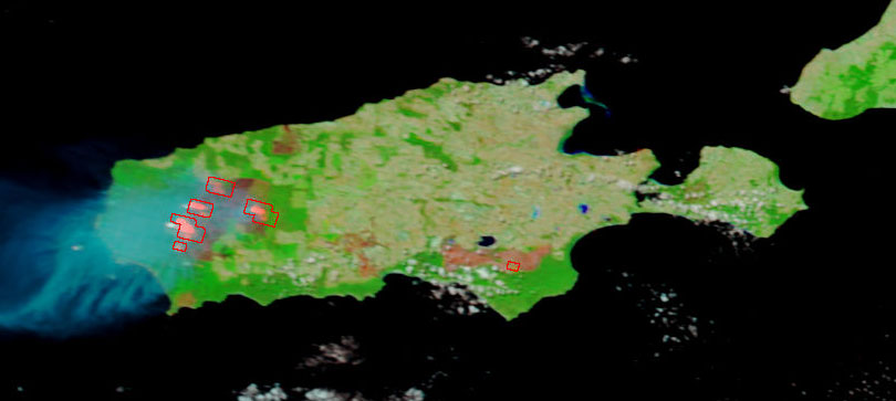
Unfortunately most NASA imagery of this sort is taken using the MODIS sensor which has only 250m resolution, so small features like back-burn areas may be impossible to see. However, the broad scope of the fire is easy to assess. As usual, clouds complicate matters. However, Terra got a half-decent look at Kangaroo Island today (Australia time):

The burnt region is much easier to see in this false-color version:

This can be compared to the false-color version of the original image taken on the 12th:
Alternatively, here’s the view a few days previously, on the 8th:

I hope these images may be of some use.
Matt
Matt Hancher
Lead, NASA/Google Planetary Content Team
Intelligent Systems Division
NASA Ames Research Center
Matthew.D.Hancher@nasa.gov


