Written Testimony of Vice Admiral Conrad Lautenbacher, NOAA Administrator – House Science Committee Hearing on NPOESS
WRITTEN TESTIMONY OF VICE ADMIRAL CONRAD C. LAUTENBACHER, JR. (U.S. NAVY, RET.) UNDER SECRETARY OF COMMERCE FOR OCEANS AND ATMOSPHERE AND NOAA ADMINISTRATOR NATIONAL OCEANIC AND ATMOSPHERIC ADMINISTRATION U.S. DEPARTMENT OF COMMERCE
OVERSIGHT HEARING ON THE NATIONAL POLAR-ORBITING OPERATIONAL ENVIRONMENTAL SATELLITE SYSTEM
BEFORE THE COMMITTEE ON SCIENCE U.S. HOUSE OF REPRESENTATIVES
NOVEMBER 16, 2005
Chairman Boehlert, Representative Gordon, and Committee members, I appreciate the opportunity to discuss with you the National Polar-orbiting Operational Environmental Satellite System (NPOESS). I am Conrad C. Lautenbacher, Jr., Under Secretary for Oceans and Atmosphere and Administrator of the National Oceanic and Atmospheric Administration (NOAA) in the Department of Commerce (DOC).
NOAA’s Satellite Programs
Satellites provide an unparalleled capability to take images and precise measurements of many aspects of vast areas of the land, sea and air in very rapid succession. Data obtained from these observing systems are essential to our ability to understand and predict changes in the Earth’s environment, and to conserve and manage coastal and marine resources. They are a key enabler to NOAA meeting its public safety, economic and environmental mission requirements.
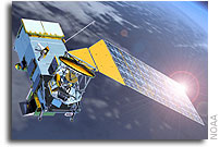
NOAA currently operates two major satellite programs. The Geostationary Operational Environmental Satellite (GOES) program provides continuous imaging and sounding data of the Western Hemisphere. This data is critical to our short-range weather forecasts and increases our ability to observe extreme weather events, such as tropical storms and tornadoes. The Polar- orbiting Operational Environmental Satellite (POES) program provides global images and atmospheric measurements a few times a day. This data is the foundation for our global weather models, which are critical to our mid- to long-range forecasts. POES satellites also contain components which receive and relay signals from search and rescue beacons to emergency officials. Information from both programs has many other applications, such as climate and ocean research, disaster monitoring, and global vegetation analysis.
What is NPOESS
Since the early 1960s, the United States has maintained two polar satellite programs, one for military use and one for civilian use. While data from both programs was freely exchanged, each
satellite program operated independently. In 1994, after a multi-year review concluded that civilian and military requirements could be satisfied by a single polar satellite program, President Clinton directed the merger of the two programs into one – NPOESS. The program was designed as a series of six satellites, with a maximum of three operating at any given time (one in an early, mid morning and early afternoon orbit). Under the NPOESS program 14 different sensors are being developed that will be distributed in various configurations depending on the satellite’s designated orbit. Several of these sensors represent significant advances over current technology.
The new NPOESS sensors will provide higher quality data, increase our ability to see through clouds, and beam the information back more often than current polar satellites. These improvements will translate into more sophisticated weather models, which will lead to better forecasts and warnings. Satellites provide over 90 percent of the data used in weather forecasting models. NPOESS also will enhance the data and products used for climate and ocean research and operations as well as monitoring space weather.
The program also includes a risk reduction component – the NPOESS Preparatory Project (NPP). NPP was designed to test several of the new sensors in space and to ensure the ground control systems work properly before launch of the first operational NPOESS satellite. Additionally, NPP should also allow us time to assimilate the new data sets into the computer weather models and other applications before NOAA would need to use them operationally. Finally, NPP should ensure continuity of certain climate records as some of the satellites maintained by the National Aeronautics and Space Administration (NASA) reach their end of life. As designed, the NPOESS program should provide the sensors to NASA, who would acquire and build the NPP spacecraft.
How is NPOESS Managed
Per a Presidential Decision Directive and the resultant DOC/DOD/NASA Memorandum of Agreement, the program is managed jointly by DOC, DOD, and NASA, with direct funding provided by DOC and DOD. At the senior level, the program is overseen by an Executive Committee (EXCOM), on which I represent the Department of Commerce, Dr. Sega represents the Department of Defense, and Dr. Griffin represents NASA. This group meets several times a year to review progress in achieving cost, schedule and performance baselines. The EXCOM also approves program plans, budgets, and policies, and ensures agency funding commitments are equitable and sustained.
To assist the EXCOM, a Tri-agency Steering Committee consisting of individuals from the same agencies meets monthly. This group acts on our behalf as a senior level management review body and recommends actions to the EXCOM, and provides guidance to the Integrated Program Office (IPO). A Senior User Advisory Group (SUAG), comprised of primary United States Government users, operates independently of the IPO and reviews, adjudicates and recommends NPOESS requirements for agency validation and subsequent Joint Agency Requirements Council (JARC) approval.
The IPO, under the direction of a System Program Director, is responsible for the planning, budgeting, development, acquisition, launch operation and management of the NPOESS program. The system is being acquired using DOD acquisition authorities and the Air Force contract is managed by the IPO. In 2002, Northrop Grumman was selected as the NPOESS prime contractor for spacecraft development, ground systems, sensor integration, and operations. Contracts for some sensors were awarded before the prime contract.
What is the Status of NPOESS
NPOESS likely is the most complex environmental satellite program ever developed. The NPOESS program presents numerous technical, developmental, integration and management challenges.
The ground system is on budget and on schedule. For the spacecraft, technical challenges have occurred in several of the sensor development efforts. The two sensors that have experienced the most serious development and manufacturing problems are the Conical Microwave Imager/Sounder (CMIS) and the Visible Infrared Imager Radiometer Suite (VIIRS).
CMIS provides all-weather sounding and imaging capability, i.e. the ability to see through the clouds. While work continues on CMIS, it is still in its initial design phase. Early problems included meeting design performance within weight constraints. We believe these technical issues are being resolved. Furthermore, we are incorporating the lessons learned from the VIIRS experience to our management approach to CMIS.
VIIRS provides the information used in many of the critical environmental data records and is the key imaging sensor delivering most of the atmospheric cloud and surface information products needed by weather forecasters. In mid-2004 during initial testing phases, we encountered significant problems showing potential design deficiencies and manufacturing process shortfalls. In late 2004, a cooling unit on the sensor, which is critical to its operation, failed during testing. These problems prompted a complete review of the sensor design, development and management. At the time, we believed the cost and schedule delays would be limited to NPP.
On March 31, 2005, however, Northrop Grumman communicated to the IPO that it would not be able to meet overall NPOESS cost and schedule baselines due to the problems encountered with development of VIIRS. Northrop Grumman formally notified the Government by letter on May 19, 2005.
Reviews and preliminary cost estimates led the Administration in September to conclude that there was a reasonable expectation that the cost to produce each satellite unit was likely to rise at least 15 percent per the notification requirement in the Nunn-McCurdy amendment.
What the Government has Done
The problems facing NPOESS are serious and we are working to contain cost growth, limit schedule delays, and reduce risk. Significant changes have been made in the overall management of the NPOESS program to improve the effectiveness of both government and contractor oversight. The Government is engaged in a search for a new NPOESS Program Director, as the System Program Director resigned in September. Since the VIIRS problems were discovered, the IPO has had an on-site presence at the contractor’s facilities and at Raytheon (the subcontractor for VIIRS), and is more involved in the day-to-day work being conducted. In terms of personnel, Northrop Grumman has assigned a new NPOESS Program Manager and Raytheon has brought in a new senior sensor management team. In addition, the EXCOM has initiated two independent reviews of the program, one to look at the problems of VIIRS impacting NPP and another – the Independent Program Assessment (IPA) – to examine the overall NPOESS program. These review teams are helping us to better understand what has gone wrong with the program and more fully explore the various options for moving forward. The review teams are exploring reducing sensor requirements and relying on other satellite systems to provide some of the requirements. At the same time, the EXCOM is working with the SUAG to understand how any changes to capabilities would impact users.
In addition to the independent programmatic reviews, the EXCOM has asked the DOD’s Cost Analysis and Improvement Group (CAIG) to provide an independent analysis of several IPA cost and schedule estimates. This group is made up of acquisition and technical experts who can help provide further confidence in the cost estimates being discussed for both the current NPOESS program and other options.
Response to Specific Questions
I would now like to respond specifically to the questions the Committee presented me in its invitation letter.
1) What is the current estimate of the cost and launch date for the first NPOESS satellite and how does that compare to the September 2003 baseline ($7.3 billion and November 2009)? What steps need to be taken to firm up the cost and schedule estimate and when will an official new baseline be available?
In 2003 and 2004, our plan was to launch NPP in October 2006, and the first NPOESS satellite in November 2009. Based on the problems discussed earlier, we expect the availability dates for NPP and the NPOESS satellites to be extended at least two years. These launch dates may be shortened or extended based on ongoing reviews of these issues and EXCOM decisions.
We anticipate a cost increase of at least 15 percent per unit, which triggered the Nunn-McCurdy notification. The EXCOM will evaluate alternatives based on information from the IPA and CAIG in December. Following EXCOM direction, the IPO will begin the process to modify the contract with the target to complete the modification by September 2006. This will culminate in an updated baseline in November 2006.
2. What program options are being considered in response to the increased cost and schedule delays? Do any of these options involve scaling back the capability of the NPOESS satellite? Would such scaling back affect the plans of other agencies to fly sensors on NPOESS?
We have reviewed numerous program options. These options include all three elements of cost, schedule and performance. For example, we considered maintaining the current budget and delaying the launches, or increasing the budget in the early years to minimize launch delays. We also looked at options that used NPOESS in only two orbits. Finally, we also looked at scaling back or deleting capability from the NPOESS satellites to reduce program cost and minimize launch delays. If we scale back the spacecraft, it could limit the size and number of total sensors flown on NPOESS.
3. It is our understanding that no options are being considered that increase spending in Fiscal Year (FY) 2006 or FY 2007. Why is that the case? Will delaying action until FY 2008 increase the lifetime cost of the NPOESS program and increase the risk that the satellite will not be ready in time to perform its mission? Is the decision to not increase spending driven purely by near-term Federal budget constraints? If so, why is NOAA assuming that funding will be more available in FY 2008?
We considered all options, including those with additional FY 2006 and FY 2007 funding. However, the IPA has concluded that additional funding in these years would not buy back any schedule delays. All options will increase the lifetime cost of the NPOESS program. Decisions were not driven by near-term budget impacts, but rather have been focused on delivering the best possible overall value for the nation.
4. If the last satellite from the current NOAA polar series fails during launch or in orbit, then, given the schedule delays anticipated for NPOESS, there could be a 19- to 36- month gap in polar satellite coverage for NOAA. If a coverage gap were to occur, what are the implications for NOAA weather forecasting capabilities? What are NOAA’s contingency plans for a gap in polar satellite coverage?
We are considering options including the delay of the launch of the last POES satellite to improve the likelihood of overlap between POES and NPOESS satellites. If the last POES fails between launch and before the first flight of NPOESS, there could be a gap for some of the polar data. NOAA is working with DOD and our European partners to determine what fallback capabilities are available. We are also examining how to use NPP to cover any potential gaps. Should all these efforts fail, we could experience some degradation to our global weather models.
Conclusion
NPOESS is a very complex acquisition program that will greatly enhance and increase our Nation’s capabilities in weather forecasting and in other important environmental research areas. We are working very hard to overcome the technical and management challenges that have occurred and we believe that viable options to rationalize the program and move forward exist.
Before we make any major decisions, however, we want to ensure we have the best information possible. We expect to have the information from the ongoing independent reviews in the next two months and will then be able to make some final decisions.
Thank you for the opportunity to speak with you today and I am prepared to answer any questions you have.


