Space Station Imagery: Mount Kazbek, Russia
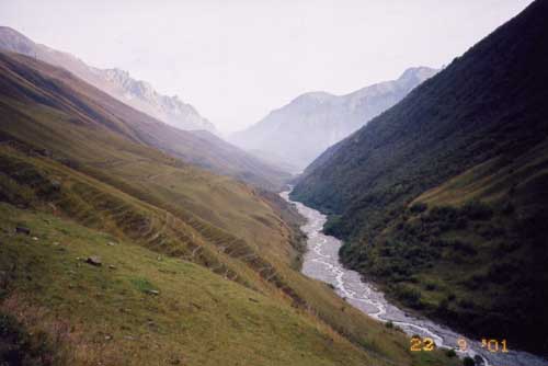 |
| The Genaldon River valley is situated above the buried villages. The bottom of the valley is now covered by ice. This photograph was taken by Olga Tutubalina on Sept. 22, 2001. Larger image |
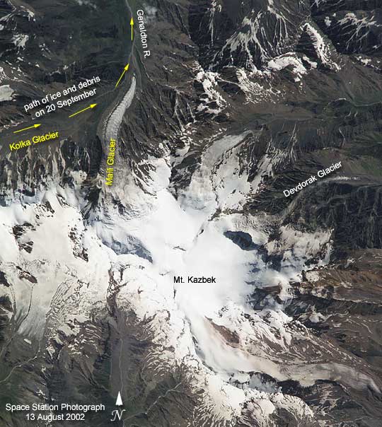
The photograph
above is of Mount Kazbek. It was taken from the International Space
Station on Aug. 13, 2002. The astronauts and cosmonauts took the
photograph at the request of the Russian URAGAN project, which is
studying changes in the world’s glaciers in response to global climate
change. Although scientists have predicted the possibility of large
glacial collapses as the climate warms, no one predicted that tragedy
would strike the mountain village of Karmadon a little more than
a month later.
On Sept. 20,
2002, a hanging glacier on the slope of Mount Dzhimarai-Khokh collapsed
onto the Kolka glacier, triggering an avalanche of ice and debris
that went over the Maili Glacier terminus, then slid over 24 kilometers
(15 miles). It buried small villages in the Russian Republic of
North Ossetia, killing dozens of people. Where the ice stopped,
the glacial debris flow dammed rivers further below. Several lakes
formed and one of them flooded a village. There, lakes are now threatening
to burst and form debris flows.
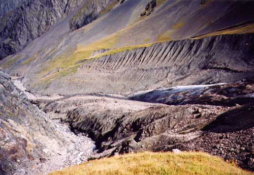 |
| The white area in the center right is the Maili Glacier terminus, which has been buried by the ice from Kolka Glacier. This photograph was taken by Olga Tutubalina on Sept. 22, 2001. Larger image |
This photograph
shows the lower part of the Kolka Glacier terminus, onto which the
glacier from Mount Dzhimarai-Khokh collapsed. The mountain itself
is further to the west. However, the Maili Glacier and its terminus,
as well as the upper part of the Genaldon River valley that was
filled by the debris slide, is very clear in the photo. In this
very detailed view, Karmadon is much further to the north.
Exactly a hundred
years ago, in 1902, the same kind of catastrophe happened in this
valley, killing 32 people. In 1969 Kolka Glacier surged, but there
were no casualties and the villages were not affected. The 1969
surge was studied by a special expedition. However, after the glacier
stabilized, research in the area stopped. It was concluded that
the 1902 catastrophe was also a result of a glacier surge. The latest
data on the 2002 catastrophe raise doubts on this conclusion. It
is possible that the 1902 event resulted from a similar cascade
of collapses.
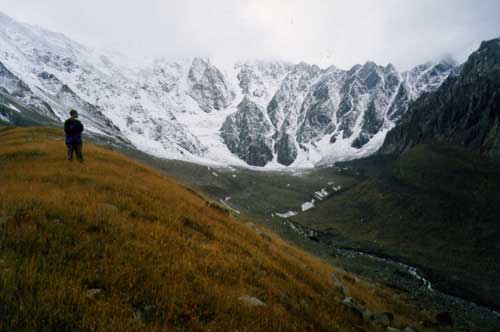 |
| This is a partial view of the Kolka Glacier (center). The photograph taken by Sergei Chernomorets on Sept. 22, 2001. Larger image |
Russian scientists
Olga Tutubalina, Dmitry Petrakov, Sergei Chernomorets (Moscow State
University) and Lev Dessinov (Russian Academy of Sciences) have
been cooperating with the NASA Crew Earth Observations project to
help interpret detailed glacier imagery captured from the International
Space Station. International Space Station crewmembers are surveying
glaciers around the world using their low orbit and high-magnification
lenses to get high spatial resolution.
Astronaut photograph
ISS005-E-09691
was provided by the Earth Sciences and Image Analysis Laboratory
at Johnson Space Center. Additional images taken by astronauts and
cosmonauts can be viewed at the NASA-JSC Gateway
to Astronaut Photography of Earth.


