NASA MODIS Image of the Day: May 4, 2010 – Heavy Rain in Assam, India
In mid- to late April 2010, torrential rains and violent winds downed electric lines, damaged homes, uprooted trees, and displaced some 150,000 people in the eastern Indian state of Assam, according to news reports.
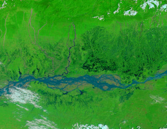
The hardest-hit area was Lakhimpur District, roughly 400 kilometers east of Assam’s principal city of Guwahati.
The MODIS on NASA’s Terra satellite captured these images of the area around Guwahati, which sits along the Brahmaputra River not far from the India-Bhutan border. The main image is from April 28, 2010, and if you move your mouse over it, you will see another image from April 16, 2010. Both images use a combination of infrared and visible light to increase the contrast between water and land. Vegetation appears bright green, and bare ground appears pinkish tan. Clouds appear sky blue. Water varies in color from electric blue to navy. The relatively light color of the Brahmaputra’s waters on April 28 likely results from the angle of sunlight, but it might also be a sign of muddy water. Expanses of standing water surround the river on April 28, and the water sits on surfaces that had been relatively dry days earlier. Tributaries to the river, both east and west of Guwahati, are swollen in the later image. The April floods in Assam were the second cluster of floods in that state in 2010, Sify News reported. The earlier round of floods struck the state the previous month, although with less severe effects.


