NASA MODIS Image of the Day: May 14, 2007 – Dust Storm over the Taklimakan Desert
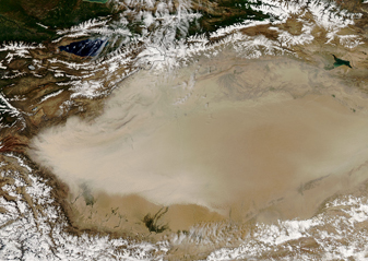
image05112007_md.jpg
On May 10, 2007, a dust storm covered most of the Taklimakan Desert in western China. The MODIS on the Aqua satellite captured an image of the storm at 07:30 UTC. The dust appears as a beige blur over the landscape and has very defined edges.
Lying in the Tarim Basin, between the Tien Shan Mountains to the north and Kunlun Mountains to the south, the Taklimakan Desert is home to one of Earth’s largest shifting-sand deserts. The basin’s lowest point is roughly 150 meters (490 feet) below sea level, and salt collects in the basin due to lack of drainage. Because of its aridity and abundant sand, this desert produces many of Asia’s dust storms.


