NASA MODIS Image of the Day: March 4, 2008 – Lake Eyre Basin, Australia
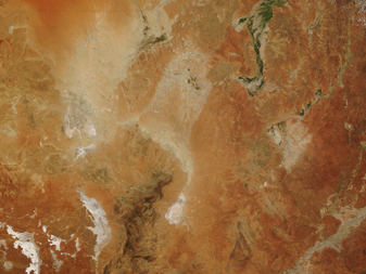
A clear day over Australia gave the MODIS on the Terra satellite a clear view on March 2, 2008.
This image shows a small portion of the Northern Territory at the top left.
At top right is Queensland. New South Wales (right) and South Australia (left) are at the bottom of the image. The Simpson Desert is at the top of the image, where the Northern territory and Queensland border New South Wales. South of the Simpson Desert is the Lake Eyre Basin. The Lake Eyre Basin covers 1/6 of Australia, including parts of Queensland, South Australia, the Northern Territory, and western New South Wales. All the rivers in this region flow inland (when there is rain to fill them), towards Lake Eyre, the lowest point in Australia. Lake Eyre is usually a dry, salt lake – it only fills approximately once a century. Lake Eyre is visible on this image as pinkish spots near central South Australia – it is in line with the border between Queensland and New South Wales.


