NASA MODIS Image of the Day: June 24, 2007 – Land Surface Temperature Product
Sometimes the ground is hot enough to burn your bare feet, sometimes it’s freezing cold and slippery, and sometimes it’s damp and cool.
Different places, times of day, seasons, and weather combine to determine the temperature of the ground, which in turn have reciprocal effects on climate, water, and ecology cycles, as well as studies of the relationship between animal/plant life and the chemical/geological composition of the Earth’s surface.
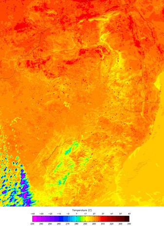
The MODIS instruments collect data about Land Surface Temperatures (LST) as part of the puzzle of how the world works and to help scientists create other MODIS data products. LST is the result of the complex interaction of energy between of the Earth’s surface and the atmosphere. Knowing where the surface is hotter or colder reveals key information about energy and heat balance on our warming planet. Because land surface temperature is one of the key parameters in the physics of the land-surface processes, it is a good indicator of the Earth’s greenhouse effect. This particular image shows the Land Surface Temperature of Southern Africa. If you move your mouse over the image, you can see what the same image looks like in true color. This image was captured by the MODIS on the Aqua satellite on May 28, 2007. For more information on the uses of LST data, please visit the technical description page on our site.


