NASA MODIS Image of the Day: January 3, 2011 – Cloud streets in the Sea of Japan
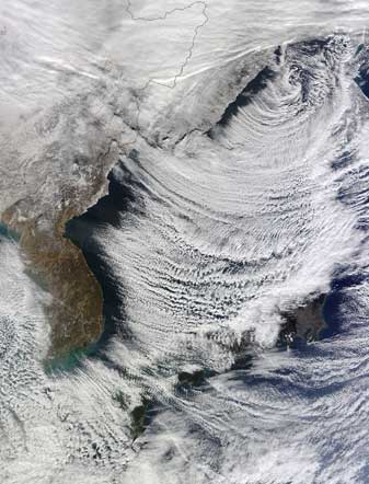
Christmas morning not only brought cold temperatures and snow to Japan, but also cloaked the warm waters of the Sea of Japan with an interesting array of cloud formations.
The Moderate Resolution Imaging Spectroradiometer (MODIS) aboard the aboard the Terra satellite passed over the region on December 25, 2010 and captured this striking true-color image.
Clouds streets are bands of cumulus clouds that orient themselves almost parallel to the low-level wind direction. They form in the lower portion of the atmosphere, within one to three kilometers from the Earth’s surface, by convention, or upward movement of air. When cold air moves over warm seas, strong convection can occur as warm air at the surfaces rises through colder air. As the moist, warm air rises, the moisture condenses and clouds are formed. On December 25th, the high temperature in Sapporo, Japan was recorded as 26°F and the low was 14°F. The surface temperature of the Sea of Japan near Sapporo was about 50°F. This difference in temperature provided excellent conditions for formations of clouds. A steady, low-level wind was the driving force that aligned the clouds into the parallel bands characteristic of cloud streets. Cloud streets in the Sea of Japan are often associated with heavy snows, which are called “sea-effect” or “lake-effect” snowfall. The lake effect occurs when extremely dry, cold air from the continent passes over the relatively warm Sea of Japan. The dry air picks up moisture and is warmed, and it rises, forming clouds. When this moisture-laden and cloud-filled air crosses a steep mountain range and rises rapidly, precipitation, in the form of heavy snowfall can be expected to occur.


