NASA MODIS Image of the Day: February 17, 2008 – The Persian Gulf
NASA MODIS Image of the Day: February 17, 2008 - The Persian Gulf
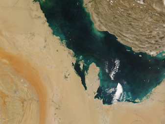
This image of the Persian Gulf region was captured by the MODIS on the Terra satellite on February 6, 2008.
features the Persian Gulf in the Middle East.
Seven countries sit on the Gulf. Visible in this image are: Iran (top right), the United Arab Emirates (bottom right), Saudi Arabia (bottom left), Qatar (the oval peninsula near the center of the image), Kuwait (top left center), and Iraq (top far left). Black lines denote country borders.


