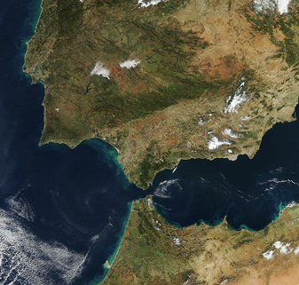
NASA MODIS Image of the Day: December 23, 2008 – The Strait of Gibraltar
NASA MODIS Image of the Day: December 23, 2008 - The Strait of Gibraltar
The Strait of Gibraltar is the waterway between the southern Iberian Peninsula and the western tip of North Africa.
At its most narrow, the strait separates Europe and Africa by just a little over 14 kilometers.
This image of the strait and the region surrounding it was captured by the MODIS on the Aqua satellite on December 19, 2008. The Strait of Gibraltar also separates the Atlantic Ocean (to the west) and the Mediterranean Sea (to the east). This brief strip of water is strategically very important, as it is the entry point from the Atlantic into the Mediterranean. Countries visible in the image are Portugal (upper left), Spain (upper right), Morocco (lower center), and Algeria (lower right).


