NASA Mars Reconnaissance Orbiter CRISM Imagery: How CRISM Sees
 Click on image to enlarge.
|
|
||||||||||
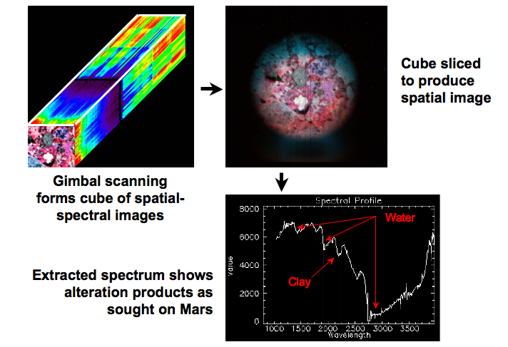
This image shows a single CRISM observation sequence of a geologic sample (a breccia), obtained during ground testing. This observation was made using a command sequence identical to what will be used inflight to observe Mars. One two-dimensional frame of CRISM data, outlined in white in the upper left panel, is a single line of a spatial image. Each element of the line has a spectrum that fills out the second dimension of the frame. A two-dimensional spatial image of a target is built up by taking successive data frames as the spectrometer field of view is swept across a target, either by scanning CRISM’s gimbal or by Mars Reconnaissance Orbiter’s along-track motion over the Martian surface. The stack of resulting data frames (shown in the upper left panel) is a multiband image, or “image cube.” The upper right panel shows a three-wavelength slice through the multiband image to create a red-green-blue image as the eye might see it. The lower right right panel shows the spectrum for a single spatial pixel from the center panel. The absorption bands present in the spectrum are due to water in the minerals present in the breccia. |
|
The Compact Reconnaissance Imaging Spectrometer for Mars (CRISM) is one of six science instruments on NASA’s Mars Reconnaissance Orbiter. Led by The Johns Hopkins University Applied Physics Laboratory, the CRISM team includes expertise from universities, government agencies and small businesses in the United States and abroad. CRISM’s mission: Find the spectral fingerprints of aqueous and hydrothermal deposits and map the geology, composition and stratigraphy of surface features. The instrument will also watch the seasonal variations in Martian dust and ice aerosols, and water content in surface materials — leading to new understanding of the climate. |
|
Credit: NASA/JPL/JHUAPL |


