NASA Mars Reconnaissance Orbiter CRISM Imagery: Dune Field in Nili Pateria
 Click on image to enlarge.
|
|
||||||||||
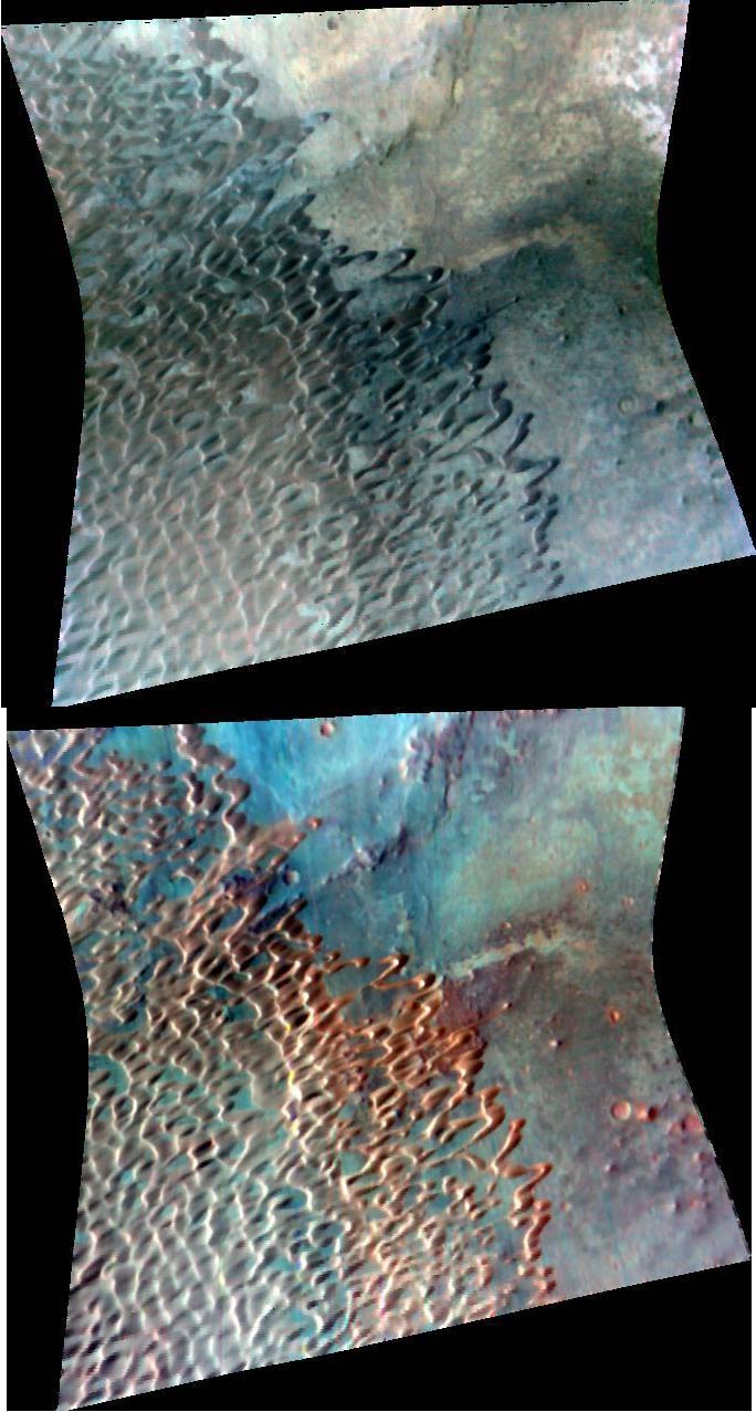
The Compact Reconnaissance Imaging Spectrometer for Mars (CRISM) took this image of the southeastern edge of a large dune field within Nili Patera, an irregularly shaped volcanic caldera that is about 65 kilometers (40 miles) in diameter. The image was acquired at 1333 UTC (8:33 a.m. EST) on Feb. 1, 2007, near 8.8 degrees north latitude, 67.3 degrees east longitude. CRISM’s image was taken in 544 colors covering 0.36-3.92 micrometers, and shows features as small as 20 meters (66 feet) across. The region covered by the image is just over 10 kilometers (6 miles) wide at its narrowest point. The top image was constructed from three visible wavelengths that correspond to what our eyes would see; the colors are stretched to bring out subtle color contrast. The bottom image is a spectral map constructed using three infrared wavelengths that usually highlight compositional variations. Areas with high concentrations of iron- and magnesium-rich igneous minerals appear red. The entire dune field, covering about 500 square kilometers, resides mainly in the southwest quadrant of the caldera, occupying approximately 15% of its floor. Some of the dune forms seen here are “barchans” — individual, crescent shaped dunes that form when winds come primarily from one direction, resulting in one slipface. The orientation of the slipfaces indicates that primary winds were coming from the east-northeast. Using images from Mars Global Surveyor’s narrow-angle camera, researchers measured approximately 400 slipfaces throughout the dune field and calculated an average azimuth of 245 degrees. Some of the barchans have elongated horns, suggesting that they experienced a slight secondary wind, or that the primary wind direction varied a little. When sufficient sand is available, barchans will coalesce, losing their individual crescentic shape. The resulting dune form, referred to as barchanoid, describes the vast majority of dunes in this image. In the lower left portion of the image, where the dune pattern is most regular, the distance from dune crest to dune crest is about 400 meters (437 yards). The relationship shown here, with barchans at the margin of a barchanoid dune field, is common on Mars. |
|
The Compact Reconnaissance Imaging Spectrometer for Mars (CRISM) is one of six science instruments on NASA’s Mars Reconnaissance Orbiter. Led by The Johns Hopkins University Applied Physics Laboratory, the CRISM team includes expertise from universities, government agencies and small businesses in the United States and abroad. CRISM’s mission: Find the spectral fingerprints of aqueous and hydrothermal deposits and map the geology, composition and stratigraphy of surface features. The instrument will also watch the seasonal variations in Martian dust and ice aerosols, and water content in surface materials — leading to new understanding of the climate. |
|
Credit: NASA/JPL/JHUAPL/USGS |


