NASA Mars Reconnaissance Orbiter CRISM Imagery: Defrosting of Russell Crater Dunes
 Click on image to enlarge.
|
|
||||||||||
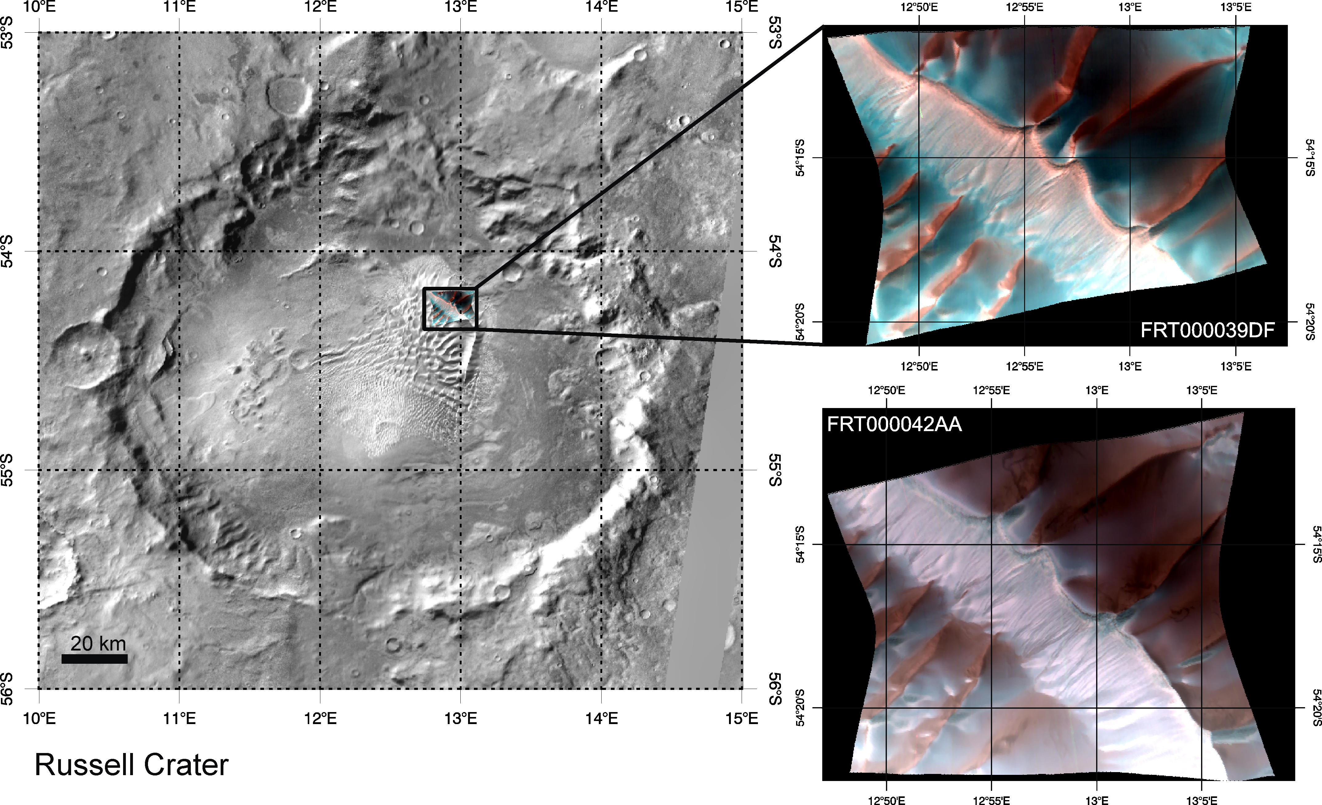
These two images (at right) were acquired by the Compact Reconnaissance Imaging Spectrometer for Mars (CRISM) 39 days apart at 19:10 UTC (2:10 PM EST) on December 28, 2006 (upper right) and at 20:06 UTC (3:06 PM EST) on February 5, 2007 (lower right). These CRISM data were acquired in 544 colors covering the wavelength range from 0.36-3.92 micrometers, and show features as small as 20 meters (about 65 feet) across. Both images are false color composites of bands at 2.5, 1.5, and 1.25 micrometers, and are nearly centered at the same location, 54.875°S, 12.919°E (upper right) and 54.895°S, 12.943°E (lower right). Each image is approximately 11 kilometers (7 miles) across at its narrowest. These are part of a series of images capturing the evolution of carbon dioxide frost on the surface of the dunes in Russell Crater. Russell Crater is one of many craters in the southern highland region of Mars that contain large areas of sand dunes. The sand in these dunes has accumulated over a very long time period – perhaps millions of years – as wind blows over the highland terrain, picking up sand in some places and depositing in others. The topography of the craters forces the wind to blow up and over the crater rims, and the wind often isn?t strong enough to keep the tiny grains suspended. This makes the sand fall to the ground and gradually pile up, and over time the surface breezes shape the sand into ripples and dunes. A similar process is at work at the Great Sand Dunes National Park and Preserve in Colorado, USA. The above left image shows a THEMIS daytime infrared mosaic of Russell Crater and the location of its (approximately) 30-kilometer wide dune field in the northeastern quadrant of the crater floor. Superposed on this view and shown enlarged at the upper right is CRISM image FRT000039DF. This CRISM image was acquired during the late Martian southern winter (solar longitude = 157.7°), and the bright blue in this false color composite indicates the presence of carbon dioxide frost (dry ice) on the dunes. Sunlight is coming from the northeast, and the sunlit faces of the dunes appear red because they show very little frost compared to the colder, more shadowed areas. Thirty-nine days later at the beginning of southern spring (solar longitude = 178.9°), CRISM image FRT000042AA (lower right) was acquired almost at the same location. Notably, the bright blue frost-rich areas are considerably smaller and subdued, with slim patches only observed on the shadowed sides of the dunes that are most protected from the warmth of the rising sun. As the southern season continues to march toward summer, all of the frost will soon be gone and won?t return until the next Martian winter. |
|
The Compact Reconnaissance Imaging Spectrometer for Mars (CRISM) is one of six science instruments on NASA’s Mars Reconnaissance Orbiter. Led by The Johns Hopkins University Applied Physics Laboratory, the CRISM team includes expertise from universities, government agencies and small businesses in the United States and abroad. CRISM’s mission: Find the spectral fingerprints of aqueous and hydrothermal deposits and map the geology, composition and stratigraphy of surface features. The instrument will also watch the seasonal variations in Martian dust and ice aerosols, and water content in surface materials — leading to new understanding of the climate. |
|
Credit: NASA/JPL/JHUAPL |


