NASA Mars Reconnaissance Orbiter CRISM Imagery: CRISM’s First ‘Targeted’ Observation of Mars
 Click on image to enlarge. |
|
||||||||||
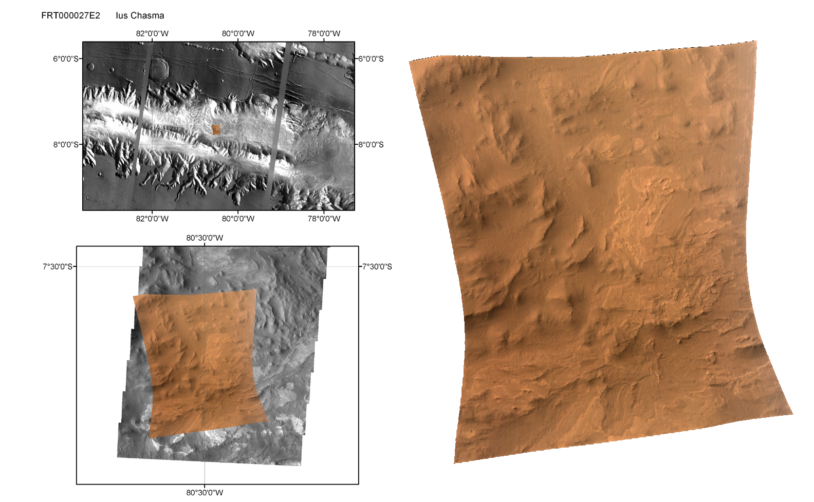
This shows the first site on Mars imaged by the Compact Reconnaissance Imaging Spectrometer for Mars (CRISM) using its full-resolution hyperspectral capability, with a “targeted image.” During a targeted image, CRISM’s movable gimbal tracks a point on the surface, and slowly scans across it for about three minutes. The image is built up one line at a time, and each pixel in the image is measured in 544 colors covering 0.36-3.92 micrometers. During this time the Mars Reconnaissance Orbiter’s range to the target starts at about 410 kilometers (250 miles), decreases to about 290 kilometers (190 miles) when the spacecraft makes its closest approach, and increases again to 410 kilometers at the end of the image. The change in geometry during image acquisition gives each CRISM targeted image a characteristic hourglass shape. This first targeted image was acquired at 1515 UTC (11:15 a.m. EDT) on Sept. 29, 2006, near 7.7 degrees south latitude, 270.5 degrees east longitude. Only minimal processing and map projection of the data have been done. At the center of the image the spatial resolution is as good as 18 meters (60 feet) per pixel. The three wavelengths shown here provide an approximate true color representation. The hourglass-shaped image covers an area about 13 kilometers (8 miles) north-south and, at the narrowest point, about 9 kilometers (5.6 miles) east-west. The upper left panel shows the image’s regional context, on a mosaic from the Mars Odyssey spacecraft’s Thermal Emission Imaging System (THEMIS) taken in infrared frequencies. This western part of the Valles Marineris canyon system is called Ius Chasma. The canyon system is about five kilometers (about three miles) deep and exposes ancient rocks from deep in the crust. The lower left panel shows local context, using a THEMIS visible-wavelengths image (THEMIS-VIS), which is comparable in resolution to CRISM data. Outcrops of light-toned layered rocks 1-2 kilometers (0.6-1.2 miles) across are set on a background of deeply eroded canyon floor, and sand dunes cover part of the site. The map-projected CRISM image, at right, shows that the site has bland color properties at visible wavelengths, and is mostly reddened by Mars’ pervasive dust or by weathering products. Faint color banding is visible in the layered rocks, hinting at compositional differences between the layers. |
|
The Compact Reconnaissance Imaging Spectrometer for Mars (CRISM) is one of six science instruments on NASA’s Mars Reconnaissance Orbiter. Led by The Johns Hopkins University Applied Physics Laboratory, the CRISM team includes expertise from universities, government agencies and small businesses in the United States and abroad. CRISM’s mission: Find the spectral fingerprints of aqueous and hydrothermal deposits and map the geology, composition and stratigraphy of surface features. The instrument will also watch the seasonal variations in Martian dust and ice aerosols, and water content in surface materials — leading to new understanding of the climate. |
|
Credit: NASA/JPL/JHUAPL/Brown University |


