NASA Mars Reconnaissance Orbiter CRISM Imagery: Chasma Boreale in the North Polar Region
 Click on image to enlarge. |
|
||||||||||
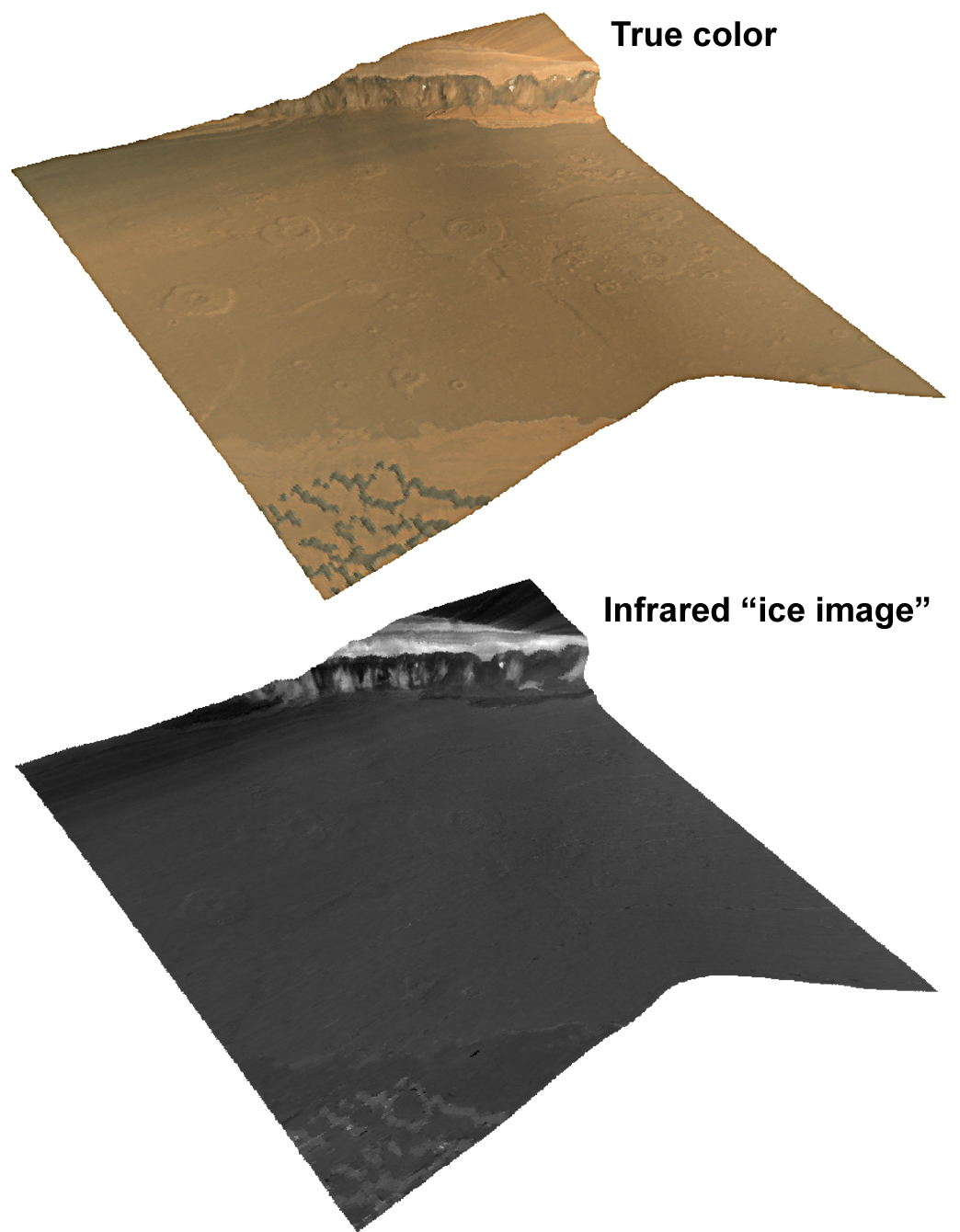
This full-resolution Compact Reconnaissance Imaging Spectrometer for Mars (CRISM) “targeted image” shows the edge of Mars’ north polar cap. The featured region, Chasma Boreale, is a valley several kilometers deep that cuts about 400 kilometers (250 miles) into the edge of the cap. CRISM acquired the image at 0851 UTC (4:51 a.m. EDT) on Oct. 1, 2006, near 84.6 degrees north latitude, 3.6 degrees east longitude. It covers an area about 13 kilometers (8 miles) long and, at the narrowest point, about 9 kilometers (5.6 miles) wide. At the center of the image, the spatial resolution is as good as 18 meters (60 feet) per pixel. The image was taken in 544 colors covering 0.36-3.92 micrometers. This image includes two renderings of the data, both draped over topography without vertical exaggeration, and viewed from a perspective diagonally above the site. At top is an approximately true-color representation. The bottom view, constructed from infrared wavelengths, shows strength of the spectral signature of ice. Brighter areas are rich in ice, and dark areas have little ice. This polar cap has long been recognized to contain layers of dust and ice, and hence has been named the “polar layered deposit.” This sits atop an underlying “basal unit.” The upper part of the basal unit is dark at visible wavelengths and steeply sloped, whereas the lower part of the basal unit is brighter, redder, and layered like the polar layered deposits. The chasma floor is cratered, and the foreground is covered by dunes that are outliers of a “sand sea” that surrounds the polar cap. The polar layered deposits and the basal unit are both exposed in a scarp about 1.1 kilometers (0.7 miles) high. CRISM’s image uncovers several previously unrecognized characteristics of the polar layered deposits and the basal unit. First, the ice-rich deposits exhibit coherent banding both at visible and infrared wavelengths; this banding shows a history of differences in the abundance of dust that accumulated in polar ice, differences in ice-grain size, or both. Second, both parts of the basal unit are depleted in ice, except for triangle-shaped regions on the side of the scarp. Third, the spectral properties of the brighter, layered lower basal unit resemble those of the polar layered deposits. In contrast, the upper basal unit differs from both of them. Finally, spectral properties of the foreground dunes closely resemble those of the darkest layers within the upper basal unit ? and may even be debris from them. |
|
The Compact Reconnaissance Imaging Spectrometer for Mars (CRISM) is one of six science instruments on NASA’s Mars Reconnaissance Orbiter. Led by The Johns Hopkins University Applied Physics Laboratory, the CRISM team includes expertise from universities, government agencies and small businesses in the United States and abroad. CRISM’s mission: Find the spectral fingerprints of aqueous and hydrothermal deposits and map the geology, composition and stratigraphy of surface features. The instrument will also watch the seasonal variations in Martian dust and ice aerosols, and water content in surface materials — leading to new understanding of the climate. |
|
Credit: NASA/JPL/JHUAPL |


