NASA Mars Picture of the Day: Springtime Dunes, 2004
Mars Global Surveyor Mars Orbiter Camera
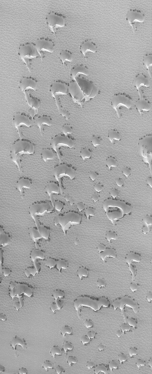
MGS MOC Release No. MOC2-694, 12 April 2004
 NASA/JPL/Malin Space Science Systems |
Today is April 12, 2004, the 43rd anniversary of the first
human flight into space (Yuri Gagarin, 1961) and
the 23rd anniversary of the first NASA Space Shuttle
flight (Columbia, 1981). Meanwhile, on Mars,
spring is in full swing in the martian northern hemisphere.
With spring comes the annual defrosting of the north polar dunes.
This Mars Global Surveyor (MGS) Mars Orbiter Camera (MOC)
image, acquired on April 7, 2004, shows a field
of small barchan (crescent-shaped) dunes covered with the remains
of wintertime frost. The dark spots around the base of each dune
mark the first signs of the spring thaw. The sand
in these dunes is dark, like the black sand beaches
of Hawaii or the dark, sandy soil of the rover, Opportunity, landing
site, but in winter and spring their dark tone is
obscured by bright carbon dioxide frost.
This picture is located near 75.9°N, 45.3°W, and
covers an area about 3 km (1.9 mi) across.
Sunlight illuminates the scene from the lower left.
Malin Space Science Systems and the California Institute of Technology
built the MOC using spare hardware from the Mars Observer mission.
MSSS operates the camera from its facilities in San Diego, California.
The Jet Propulsion Laboratory’s Mars Surveyor Operations Project
operates the Mars Global Surveyor spacecraft with its industrial
partner, Lockheed Martin Astronautics, from facilities in Pasadena,
California and Denver, Colorado.


