NASA Mars Image of the Day: First MOC Public Requested Image: Caldera of Pavonis Mons
Mars Global Surveyor Mars Orbiter Camera
MGS MOC Release No. MOC2-481, 12 September 2003
|

|
NASA/JPL/Malin Space Science Systems
Mars Global Surveyor (MGS) first began to orbit the red planet
six years ago today on 12 September 1997. More than 120,000 Mars Orbiter
Camera (MOC) images have been obtained, with the high resolution
camera covering about 3% of the planet.
Recently, in August 2003, the MOC team began accepting
public suggestions for areas on Mars to be imaged by the
high resolution camera. The goal of the MOC Public Target
Request effort is to cast a wide net to enhance the science
return of the experiment.
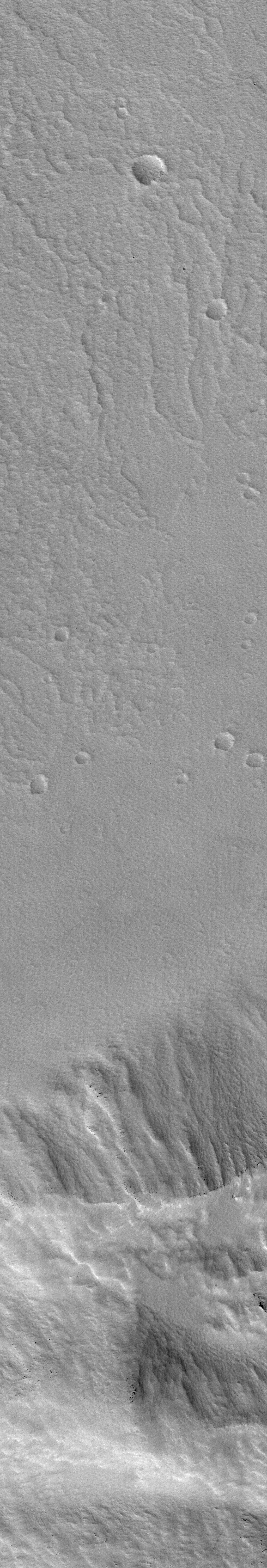
On 4 September 2003, MGS MOC acquired its first images that were
suggested through the public target program. Shown here are two
pictures, acquired at the same time by the MOC. The first (left)
is the public-requested high resolution image obtained by MOC’s
narrow angle camera. The second (right) is a context image taken
by MOC’s red wide angle camera. The white box in the context
image indicates the location of the high resolution view. In both
of these images, north is toward the top/upper right and sunlight
illuminates them from the lower left.
The image pair shows details of the summit
caldera of the martian volcano, Pavonis Mons. The caldera formed
by collapse as molten rock withdrew deep within the volcano, some
time in the past. The high resolution image shows that the caldera
floor and walls are presently covered by a thick (perhaps a meter/yard
or more) mantle of textured dust. Dark dots are
boulders that are poking out from within this dust mantle in several
areas on the lower caldera wall. This image partially overlaps a
previous, lower-resolution view of the caldera, thus providing a
close-up view at 1.5 meters (5 feet) per pixel (see
E10-01691 or a smaller sub-frame in
E10-01691sub for the lower-resolution
image).
Pavonis Mons stands about 14 km (8.7 mi) above the martian datum
(0 elevation), or roughly 6 km (3.7 mi) above its surrounding terrain.
The high resolution image covers an area 1.5 km (0.9 mi) across
by about 9 km (5.6 mi) long; the context frame is about 115 km (71 mi)
across and down. The high resolution image is located
near the equator at 0.4°N, 112.8°W.
Suggestions for MOC images of Mars are collected through the
Mars Orbiter Camera Target Request Site. Each request is checked by the MOC science/operations
team, and then placed in a database where the request waits
until some time in the future when the spacecraft is predicted to
fly over the suggested location. Because the high resolution camera
field of view is so small (maximum is 3 km –1.9 mi– wide), any
given request might wait for weeks, months, or even several years
before it is overflown by the MGS spacecraft.
Images received through this program will be placed online once
per month at http://www.msss.com/mars_images/moc/publicresults/ — the next group
of public images is anticipated to be posted in mid/late October 2003.
Malin Space Science Systems and the California Institute of Technology
built the MOC using spare hardware from the Mars Observer mission.
MSSS operates the camera from its facilities in San Diego, California.
The Jet Propulsion Laboratory’s Mars Surveyor Operations Project
operates the Mars Global Surveyor spacecraft with its industrial
partner, Lockheed Martin Astronautics, from facilities in Pasadena,
California and Denver, Colorado.


