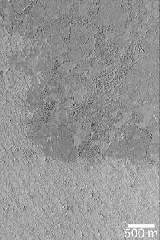
Mars Picture of the Day: Exhuming Platy Plains
Mars Global Surveyor
Mars Orbiter Camera
MGS MOC Release No. MOC2-377, 31 May 2003
 NASA/JPL/Malin Space Science Systems |
The vast plains of Mars located south of Cerberus and the Elysium
volcanoes have a platy, textured surface thought to have
formed by floods of thick mud or, more likely, very fluid lava.
This Mars Global Surveyor (MGS) Mars Orbiter Camera (MOC) image
shows that the platy plain—which is the darker surface covering
most of the northern two-thirds of this picture—is being exhumed
from beneath a brighter material. The small ridges in the bright
material are yardangs, a landform created by wind erosion.
Wind is slowly eroding the bright material away, revealing the
darker, platy surface below.
This area is located
near 4.3°N, 208.5°W.
Sunlight illuminates the scene from the
left/lower left.
Malin Space Science Systems and the California Institute of Technology
built the MOC using spare hardware from the Mars Observer mission.
MSSS operates the camera from its facilities in San Diego, California.
The Jet Propulsion Laboratory’s Mars Surveyor Operations Project
operates the Mars Global Surveyor spacecraft with its industrial
partner, Lockheed Martin Astronautics, from facilities in Pasadena,
California and Denver, Colorado.


