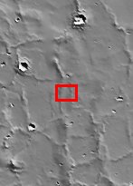
Mars Odyssey THEMIS Image: Viking 1 Landing Site in Chryse Planitia – Visible Image
 |
|
 The date July 20 marks two major milestones in humanities grand push to explore the frontier of space. On this date, in 1969, the Apollo 11 lunar module Eagle landed the first men (Neil Armstrong and Edwin ‘Buzz’ Aldrin) on another celestial body, the Moon. In 1976, seven years to the day, the robotic Viking 1 Lander made the first successful landing on the ruddy rock strewn surface of Mars. To commemorate these milestones the THEMIS Team is releasing both an IR (Infra-Red) and Visible image of the Viking 1 landing site. THEMIS is currently imaging landing sites for future robotic missions including the twin Mars Exploration Rovers set to touchdown in January 2004. All of these missions anticipate the day when, hopefully in the not too distant future, astronauts will land on the red planet. So as we reflect on our rich tradition of space exploration let us also dream and plan on a wondrous future exploring the mysterious red planet. The date July 20 marks two major milestones in humanities grand push to explore the frontier of space. On this date, in 1969, the Apollo 11 lunar module Eagle landed the first men (Neil Armstrong and Edwin ‘Buzz’ Aldrin) on another celestial body, the Moon. In 1976, seven years to the day, the robotic Viking 1 Lander made the first successful landing on the ruddy rock strewn surface of Mars. To commemorate these milestones the THEMIS Team is releasing both an IR (Infra-Red) and Visible image of the Viking 1 landing site. THEMIS is currently imaging landing sites for future robotic missions including the twin Mars Exploration Rovers set to touchdown in January 2004. All of these missions anticipate the day when, hopefully in the not too distant future, astronauts will land on the red planet. So as we reflect on our rich tradition of space exploration let us also dream and plan on a wondrous future exploring the mysterious red planet.
This 4 framelet image is part of a 5 band image sequence. This image primarily contains plains, wrinkle ridges and craters. Some craters have ripples on their floors, which are probably dunes while other craters have some type of deposit on their floors. These deposits are most likely aeolian in nature. In places the wrinkle ridges appear to be buried or mantled with material that may be either volcanic and or fluvial in origin. The lander’s view of the surface shows an undulating rocky surface with some finer grained materials present, and distant crater rims and wrinkle ridges.
Mars Surface Image Credit: NASA [Source: ASU THEMIS Science Team] |
NASA’s Jet Propulsion Laboratory manages the 2001 Mars Odyssey mission for NASA’s Office of Space Science, Washington, D.C. The Thermal Emission Imaging System (THEMIS) was developed by Arizona State University, Tempe, in collaboration with Raytheon Santa Barbara Remote Sensing. The THEMIS investigation is led by Dr. Philip Christensen at Arizona State University. Lockheed Martin Astronautics, Denver, is the prime contractor for the Odyssey project, and developed and built the orbiter. Mission operations are conducted jointly from Lockheed Martin and from JPL, a division of the California Institute of Technology in Pasadena.
Image Credit: NASA/JPL/Arizona State University
| Parameter | Value | Parameter | Value | |
|---|---|---|---|---|
| Latitude | 22.3 |   | Instrument | VIS |
| Longitude | 48.2W (311.8E) |   | Resolution (m) | 19 |
| Image Size (pixels) | 672×1037 |   | Image Size (km) | 12.8×19.7 |


