Mars Odyssey THEMIS Image: Terra Meridiani 10-18-2002
 |
|
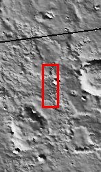
| This image is located near the equator and the prime meridian of Mars in a region called Terra Meridiani. This is a unique area of Mars that displays layers of material that appear to be in the process of being stripped away. This is exposing another layer of material directly underneath that is visible in the central portion of the image. Measurements from another instrument in orbit around Mars, the Thermal Emission Spectrometer on the Mars Global Surveyor, indicate that this region has a high concentration of a mineral called hematite. Grey hematite can form in both volcanic and water rich environments. It is not certain exactly how this mineral formed on Mars, but its presence along with the layering seen in this region makes this region of Mars particularly interesting. Among other possibilities, these layers could be volcanic ash deposits or plausibly sediments deposited in water. This region of Mars is very old and whatever process took place here, it happened long ago. This is one of the principal candidate sites for the next rover mission that will be sent to Mars in 2003. [Questions? Email images@themis.asu.edu] [Source: ASU THEMIS Science Team] |
NASA’s Jet Propulsion Laboratory manages the 2001 Mars Odyssey mission for NASA’s Office of Space Science, Washington, D.C. The Thermal Emission Imaging System (THEMIS) was developed by Arizona State University, Tempe, in collaboration with Raytheon Santa Barbara Remote Sensing. The THEMIS investigation is led by Dr. Philip Christensen at Arizona State University. Lockheed Martin Astronautics, Denver, is the prime contractor for the Odyssey project, and developed and built the orbiter. Mission operations are conducted jointly from Lockheed Martin and from JPL, a division of the California Institute of Technology in Pasadena.
Image Credit: NASA/JPL/Arizona State University
| Parameter | Value | Parameter | Value | |
|---|---|---|---|---|
| Latitude | 3.8 |   | Instrument | VIS |
| Longitude | 357.7E (2.3W) |   | Resolution (m) | 19 |
| Image Size (pixels) | 3043×1239 |   | Image Size (km) | 57.8×23.5 |


