Mars Odyssey THEMIS Image: Floor of Juventae Chasma
 |
|
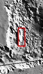
| Juventae Chasma is an enormous box canyon (250 km X 100 km) which opens to the north and forms the outflow channel Maja Vallis. Most Martian outflow channels such as Maja, Kasei, and Ares Valles begin at point sources such as box canyons and chaotic terrain and then flow unconfined into a basin region. This image captures a portion of the western floor of Juventae Chasma and shows a wide variety of landforms. Conical hills, mesas, buttes and plateaus of layered material dominate this scene and seem to be ?swimming? in vast sand sheets. The conical hills have a spur and gully topography associated with them while the flat topped buttes and mesas do not. This may be indicative of different materials that compose each of these landforms or it could be that the flat-topped layer has been completely eroded off of the conical hills thereby exposing a different rock type. Both the conical hills and flat-topped buttes and mesas have extensive scree slopes (heaps of eroded rock and debris). Ripples, which are inferred to be dunes, can also be seen amongst the hills. No impact craters can be seen in this image, indicating that the erosion and transport of material down the canyon wall and across the floor is occurring at a relatively rapid rate, so that any craters that form are rapidly buried or eroded. [Source: ASU THEMIS Science Team] |
NASA’s Jet Propulsion Laboratory manages the 2001 Mars Odyssey mission for NASA’s Office of Space Science, Washington, D.C. The Thermal Emission Imaging System (THEMIS) was developed by Arizona State University, Tempe, in collaboration with Raytheon Santa Barbara Remote Sensing. The THEMIS investigation is led by Dr. Philip Christensen at Arizona State University. Lockheed Martin Astronautics, Denver, is the prime contractor for the Odyssey project, and developed and built the orbiter. Mission operations are conducted jointly from Lockheed Martin and from JPL, a division of the California Institute of Technology in Pasadena.
Image Credit: NASA/JPL/Arizona State University
| Parameter | Value | Parameter | Value | |
|---|---|---|---|---|
| Latitude | -3.6 |   | Instrument | VIS |
| Longitude | 61.9W (298.1E) |   | Resolution (m) | 19 |
| Image Size (pixels) | 3043×1239 |   | Image Size (km) | 57.8×23.5 |


