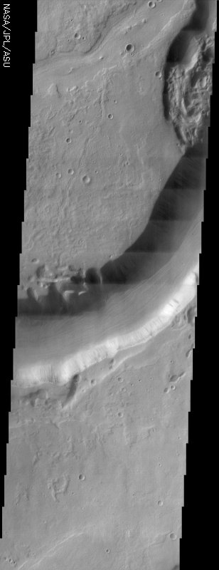
Mars Odyssey THEMIS Image: Dao Vallis
 |
|
| This THEMIS visible image shows Dao Vallis, a large outflow channel that starts on the southeast flank of a large volcano called Hadriaca Patera and runs for 1000 kilometers southwest into the Hellas impact basin. The channel is up to 20 kilometers wide near its source, but narrows downstream. As can be seen in the context image, the part of Dao Vallis imaged by THEMIS is actually one of the most narrow.
It is believed that Dao Vallis was carved by a combination of surface and Because the source region of Dao Vallis is the flank of a volcano, it is [Questions? Email images@themis.asu.edu] [Source: ASU THEMIS Science Team] |
NASA’s Jet Propulsion Laboratory manages the 2001 Mars Odyssey mission for NASA’s Office of Space Science, Washington, D.C. The Thermal Emission Imaging System (THEMIS) was developed by Arizona State University, Tempe, in collaboration with Raytheon Santa Barbara Remote Sensing. The THEMIS investigation is led by Dr. Philip Christensen at Arizona State University. Lockheed Martin Astronautics, Denver, is the prime contractor for the Odyssey project, and developed and built the orbiter. Mission operations are conducted jointly from Lockheed Martin and from JPL, a division of the California Institute of Technology in Pasadena.
Image Credit: NASA/JPL/Arizona State University
| Parameter | Value | Parameter | Value | |
|---|---|---|---|---|
| Latitude | -35.4 |   | Instrument | VIS |
| Longitude | 90.9E (269.1W) |   | Resolution (m) | 19 |
| Image Size (pixels) | 3061×1199 |   | Image Size (km) | 58.2×22.8 |
| Solar Longitude | 329.6 |   | Emission Angle | 2.9 |
| Incidence Angle | 67.2 |   | Phase Angle | 69.2 |
| North Azimuth | 262.9 |   | Slant Distance | 428.4 km |
| Local Solar Time | 8.8 |   | Sun Azimuth | 114.8 |


