Mars Odyssey THEMIS Image: Coprates Chasma Landslide
 |
|
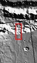
| Coprates Chasma comprises the central portion of the Valles Marineris canyon system complex. This image of the southern wall of Coprates Chasma contains a landslide deposit with dunes over portions of slide. Landslides have very characteristic morphologies on Earth, which they also display on Mars. These morphologies include a distinctive escarpment at the uppermost part of the landslide–called a head scarp (seen at the bottom of this image), a down-dropped block of material below that escarpment that dropped almost vertically, and a deposit of debris that moved away from the escarpment at high speed. In this example, the wall rock displayed in the upper part of the cliff contains spurs and chutes created by differing amounts of erosion. The actual landslide deposit is delineated by its fan-shape and lobate margins. The dunes subsequently marched upon the landslide deposit.
[Questions? Email images@themis.asu.edu] [Source: ASU THEMIS Science Team] |
NASA’s Jet Propulsion Laboratory manages the 2001 Mars Odyssey mission for NASA’s Office of Space Science, Washington, D.C. The Thermal Emission Imaging System (THEMIS) was developed by Arizona State University, Tempe, in collaboration with Raytheon Santa Barbara Remote Sensing. The THEMIS investigation is led by Dr. Philip Christensen at Arizona State University. Lockheed Martin Astronautics, Denver, is the prime contractor for the Odyssey project, and developed and built the orbiter. Mission operations are conducted jointly from Lockheed Martin and from JPL, a division of the California Institute of Technology in Pasadena.
Image Credit: NASA/JPL/Arizona State University
| Parameter | Value | Parameter | Value | |
|---|---|---|---|---|
| Latitude | -15.6 |   | Instrument | VIS |
| Longitude | 304.2E (55.8W) |   | Resolution (m) | 19 |
| Image Size (pixels) | 3061×1231 |   | Image Size (km) | 58.2×23.4 |


