Mars Odyssey THEMIS Image: Claritas Fossae
 |
|
| The Science | The Story | |||
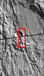
| The eastern rim of this unnamed crater in Claritas Fossae is very degraded. This indicates that this crater is very ancient and has been subjected to erosion and subsequent bombardment from other impactors such as asteroids and comets. One of these later (younger) craters is seen in the upper right of this image superimposed upon the older crater rim material. Note that this smaller younger crater rim is sharper and more intact than the older crater rim. This region is also mantled with a blanket of dust. This dust mantle causes the underlying topography to take on a more subdued appearance. [Source: ASU THEMIS Science Team] | Not every crater on Mars has a name. The one in this image doesn’t. What would you name it if you could?
That’s what planetary scientists ask themselves when they come across such features. If they think of a good name, they can submit it for approval to a group of world astronomers who are members of the International Astronomical Union. There are special rules, though, so not any name can be selected. The selection committee especially wants to make sure that all world cultures are represented. While this crater may not have a name, the region it lies in does. It is called Claritas Fossae. “Claritas” is the Latin word for “bright.” “Fossae” are long, narrow, shallow depressions that mark the region. You can see these best in the context image to the right. You can tell just by looking at this crater that it is very ancient. Its rim is very degraded from erosion and bombardment from other impactors such as asteroids and comets. Compare its roughened rim to the smoother outline of the small crater on the rim’s edge (upper right). The smoother rim of the small one means that it is considerably younger than its older, choppier neighbor. You know it was certainly created after the large crater because it lies on top of the rim. Other than the old and young generations of craters, the surface looks pretty uniform in hue and perhaps even a little dull. That’s because a coating of dust lies over the area, masking some of the contrasts in terrain that might lie beneath. [Questions? Email marsoutreach@jpl.nasa.gov] [Source: NASA/JPL Mars Outreach] | |||
NASA’s Jet Propulsion Laboratory manages the 2001 Mars Odyssey mission for NASA’s Office of Space Science, Washington, D.C. The Thermal Emission Imaging System (THEMIS) was developed by Arizona State University, Tempe, in collaboration with Raytheon Santa Barbara Remote Sensing. The THEMIS investigation is led by Dr. Philip Christensen at Arizona State University. Lockheed Martin Astronautics, Denver, is the prime contractor for the Odyssey project, and developed and built the orbiter. Mission operations are conducted jointly from Lockheed Martin and from JPL, a division of the California Institute of Technology in Pasadena.
Image Credit: NASA/JPL/Arizona State University
| Parameter | Value | Parameter | Value | |
|---|---|---|---|---|
| Latitude | -35.1 |   | Instrument | VIS |
| Longitude | 103.2W (256.8E) |   | Resolution (m) | 19 |
| Image Size (pixels) | 3061×1199 |   | Image Size (km) | 58.2×22.8 |


