Mars Odyssey THEMIS Image: Canyons and Mesas of Aureum Chaos
 |
|
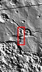
| This image contains a portion of Aureum Chaos located just south of the Martian equator. This fractured landscape contains canyons and mesas with two large impact craters in the upper left. The largest crater is older than the one above it. This is readily evident because a landslide deposit created by the smaller crater’s impact is seen on the larger crater’s floor. The overall scene has a rather muted appearance due to mantling by dust. Some small dark streaks can also be seen in this scene. These small dark streaks suggest that the materials covering this area occasionally become unstable and slide. Ridges of resistant material also can be observed in the walls of the canyons. The wall rock seen in the upper part of the cliffs appears to be layered. Classic spur and gully topography created by differing amounts of erosion and possibly different rock types is also visible here. One important observation to be made in this region is that there are no gullies apparent on the slopes such as those seen in Gorgonum Chaos (June 11th daily image). Latitude appears to play a major role in gully occurrence and distribution, with the gullies being predominately found pole ward of 30°. [Source: ASU THEMIS Science Team] |
NASA’s Jet Propulsion Laboratory manages the 2001 Mars Odyssey mission for NASA’s Office of Space Science, Washington, D.C. The Thermal Emission Imaging System (THEMIS) was developed by Arizona State University, Tempe, in collaboration with Raytheon Santa Barbara Remote Sensing. The THEMIS investigation is led by Dr. Philip Christensen at Arizona State University. Lockheed Martin Astronautics, Denver, is the prime contractor for the Odyssey project, and developed and built the orbiter. Mission operations are conducted jointly from Lockheed Martin and from JPL, a division of the California Institute of Technology in Pasadena.
Image Credit: NASA/JPL/Arizona State University
| Parameter | Value | Parameter | Value | |
|---|---|---|---|---|
| Latitude | -1.6 |   | Instrument | VIS |
| Longitude | 26.8W (333.2E) |   | Resolution (m) | 19 |
| Image Size (pixels) | 3043×1240 |   | Image Size (km) | 57.8×23.6 |


