Mars Odyssey THEMIS Image: Buried Crater
 |
|
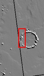
| With a location roughly equidistant between two of the largest volcanic constructs on the planet, the fate of the ~50 km impact crater in this image was sealed. It has been buried to the rim by lava flows. The MOLA context image shows pronounced flow lobes surrounding the crater, a clear indication of the most recent episode of volcanism that could have contributed to its infilling. Breaches in the rim are clearly evident in the image and suggest locations through which lavas could have flowed. These openings appear to be limited to the west side of the crater. Other craters in the area are nearly obliterated by the voluminous lava flows, further demonstrating one of the means by which Mars renews its surface. [Questions? Email images@themis.asu.edu] [Source: ASU THEMIS Science Team] |
NASA’s Jet Propulsion Laboratory manages the 2001 Mars Odyssey mission for NASA’s Office of Space Science, Washington, D.C. The Thermal Emission Imaging System (THEMIS) was developed by Arizona State University, Tempe, in collaboration with Raytheon Santa Barbara Remote Sensing. The THEMIS investigation is led by Dr. Philip Christensen at Arizona State University. Lockheed Martin Astronautics, Denver, is the prime contractor for the Odyssey project, and developed and built the orbiter. Mission operations are conducted jointly from Lockheed Martin and from JPL, a division of the California Institute of Technology in Pasadena.
Image Credit: NASA/JPL/Arizona State University
| Parameter | Value | Parameter | Value | |
|---|---|---|---|---|
| Latitude | 27 |   | Instrument | VIS |
| Longitude | 190.2E (169.8W) |   | Resolution (m) | 19 |
| Image Size (pixels) | 3025×1213 |   | Image Size (km) | 57.5×23 |


