Keith Cowing’s Devon Island Journal – 20 July 2002: Mars airplanes and communicating with Earth
|
Click on Image for larger view. Images Copyright |
 NASA ARC UAV being prepared for flight |
 Paul Chambers flying the UAV by remote control |
 Paul Chambers holding the UAV while a Twin Otter prepares for take off on the landing strip |
 CRC satellite dish through which HMP Internet and network connections are routed |
 Satellite dish and tent housing communication gear located on Maynard Hill |
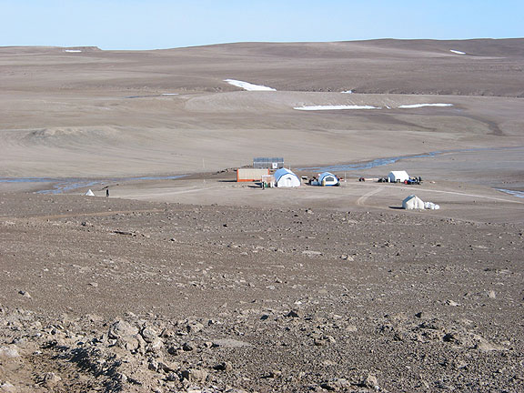 View of Base Camp from Maynard Hill |
 HMP Chief Field Engineer Steve Braham inside of tent housing satellite communications gear |
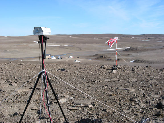 SpaceRef webcam pointed at windsock and HMP landing strip |
 Webcam view of landing strip |
There are a number of pervasive sounds on Devon Island. During the day power tools at the greenhouse, ATVs moving in and out of camp, and the main generator droning away up on the Hill half way to the runway while another (smaller) generator whines away up on Maynard Hill powering our communications gear.
Just as I thought I had mastered life in Base Camp I woke to a surprise: a new noise.
The sound was that of a small UAV buzzing about over nearby von Braun Planitia. The pane team had tired to fly the day before but had been thwarted by wind. The stillness of the early morning was an obvious time to try and fly.
Having been awakened I pulled on my clothes and began the walk to work. This has to be one of the wildest commutes to work I have ever had – with the possible exception of working in California at Rockwell International in the early 1980’s when I walked past Space Shuttle orbiters Discovery and Atlantis (and the parts that would one day become Endeavour) in various stages of assembly – every day.
As I head down the path to a small stream of snowmelt, the Mars Society’s Habitat stands directly before me. To the left is the rock outcropping we call “The Fortress”. Swinging your eyes to the left you see a greenhouse and the tents of base camp – all surrounded by a very Martian (sans the color) looking landscape. Indeed, the layout of tents, antennas, and other gear is reminiscent of some of the artist’s conceptions of a Mars Base – with the exception that the tents would be replaced by habitat modules.
At one during the day, while I walked through Base Camp, I noticed a new – and distinct smell – that of acetic acid (Vinegar). After a few minutes the source revealed itself: Charles Cockell from the British Antarctic Survey (HMP Chief Biologist) was using a hair dryer to accelerate the evaporation of acetic acid from some biological samples he was processing.
Later in the day I walked over to watch another test flight of the UAV from closer up. The UAV itself is rather unremarkable in that it looks just like a single engine Cessna – with the exception that it has a wingspan of only 175 centimeters. The small plane and an operator (Paul Chambers) were provided by MicroPilot under contract to NASA.
The plane took off under manual control by Paul while Benton Lau from NASA ARC and Emily Lakdawalla (a geologist from the Planetary Society) looked on and checked on the plane’s GPS and video systems. The intent was to eventually have the plane fly autonomously using an electronic map of Devon Island’s surface features and the GPS system to navigate.
The flying of a specific Mars airplane prototype was not the core purpose of the project. Rather, this off-the-shelf UAV provided an existing platform for some more fundamental research on how an airplane could be operated on Mars. The core focus of this UAV research is a project called the “Bio-inspired Engineering for Exploration System” (or BEES for short). BEES is managed by Larry Young and Benton Lau at NASA ARC.
Eventually, this research could lead to the development of onboard computer systems i.e. a “smart chip” for remote research systems (such as a Mars airplane) that mimic the biological control systems (some call this “wetware”) that living organisms use.
In the afternoon I went up to the top of Maynard Hill by ATV with Stephen Braham. Steve is the HMP Chief Field Engineer and Acting Principal Investigator. Steve has a number of interesting projects underway at Simon Frasier University. While trained as an astrophysicist, Steve’s passion surrounds developing the means whereby communication and computation capabilities are developed for use by unmanned and manned space missions. As is the case with everyone at HMP, Mars is one place Steve focuses much of his efforts on.
The communications array we have on Devon Island is impressive. A large satellite dish and a tent full of gear affords some rather robust communications capabilities. Once the bugs that go with any experimental and expeditionary operation got worked out, we had the capability to interact with the rest of the world little different (often better) than any of us would back home.
This system is not here just for web surfing. Indeed, it is a crucial part of the advanced communications research being conduced as part of the HORSE project by NASA Ames Research Center. During the course of established repeater stations overlooking scientific research sites, the team was able to achieved data throughput rates of 11 mbps. What was impressive about this was that this was achieved without direct line of sight.
Given that we are in a rather sparse location, we need to provide everything needed to power these systems. One of the chores that goes with this system is feeding the generator that powers the gear. This task is shared by Steve, Victor Rundquist (from NASA Ames Research Center) and others on a daily basis. As such, it is a regular feature of late evening life here to hear someone riding an ATV up to the top of the hill every night around 11:00 pm.
While I was atop this hill I took a number of images with my camera that would later be stitched together to create Quicktime panoramas. This location gives the best vista I have yet to see. To the southeast you can see Haughton Crater. To the east is the mars Society’s Hab. As you look north, you see The Fortress and the landing strip. Looking north you see Base Camp – and beyond it, Von Braun Planitia. To the west is Tent City. Just beyond that is Pete Conrad Valley.
Quicktime panorama: View from atop Maynard Hill 20 July 2002. 270 degree pan. R-L: Haughton Crater, The Fortress, Base Camp, Tent City, windsock and webcam. [Download] |

Again, as I have frequently mentioned, if you ignore the blue sky, this vista is most Martian. Although Haughton Crater has undergone significant erosion, becoming less distinct in the process, seeing the edge of this vast depression still adds to the otherworldly character of this place.
One of the things I wanted to get was pictures of while atop Maynard Hill was one of SpaceRef’s live webcams. This year, in order to help the folks at First Air (the charter company upon whom we depend for our airborne logistics) we positioned this webcam so as to allow First Air (and others) to observe conditions on Devon Island from their offices back in Resolute.
Combined with our weather station near the runway, and a windsock directly in view of the webcam, First Air found it a lot easier to gauge what conditions were actually like on a moment-to-moment basis. This information was augmented by calls on the satellite phone by our Base Camp Manager, John Schutt.
Related Links
- NASA Haughton-Mars Project
- SpaceRef
- SpaceRef Mars on Earth coverage
- Arthur Clarke Mars Greenhouse
- MarsToday.com
- Astrobiology.com
2003
- 17 Jun 2003: Preface: Moving from Green to Grey
- 3 Jul 2003: Waiting in Resolute
- 3-5 July 2003: Arrival and Getting to Work
- 6 July 2003:Getting in the Groove
- 7 July 2003: Part 1: Being here – and being there.
- 7 July 2003: Part 2: Getting Out of Base Camp
- 8 July 2003: Infrastructure
- 9 July 2003: Re-connected; Planting Seeds
- 17 July 2003: Rover Arrival
- 18 July 2003: Wind
- 19 July 2003: Illness, Good Food, and Morale
- 20 July 2003: Arctic Memorials and Starship Yearnings
- 20 July 2003: Going Home
- 21 July 2003: Departure – and One Last Dedication
- 24 July 2003: 24 July 2003: Homeward Bound – In Slow Motion
- 26 August 2003: Home +30
2002
- 8 Jul 2002: Arrival
- 9 Jul 2002: Getting acquainted – and down to work
- 10 Jul 2002: Mars carpentry
- 11 Jul 2002: Lexan Kites, shotguns, and Driver’s Ed
- 12 Jul 2002: Building and exploring
- 13-15 Jul 2002: Building a Mars greenhouse on Earth
- 16 Jul 2002: Sealing Greenhouses on Earth – and Mars; 6 Wheeled Rovers
- 17 Jul 2002: Greenhouse Dedication, Fishing, and Mystery Food
- 18 Jul 2002: Giving Blood, Eternal Light, and an Evening Commute
- 19 Jul 2002: The Hottest Place on Devon Island, T-shirts, a Star Trek hello
- 20 Jul 2002: Mars Airplanes and Communicating With Earth
- 21 Jul 2002: Visiting ministers, missing ‘green’, and crater tours
- 22 Jul 2002: The hottest place on Devon Island
- 23 Jul 2002: Farewells, Birthdays, and Bartering
- 24 Jul 2002: EVAs, movies – and ‘being here’
- 25 Jul 2002: Russian TV, webcam privacy, and being on Mars for a few minutes
- 26 Jul 2002: Cold Feet, Chocolate, and Home Cooking
- 27 Jul 2002: Anchors and anemometers
- 28 Jul 2002: Drilling into permafrost; leaving footprints for eternity
- 29 Jul 2002: Showering near the North Pole; one last look around
- 30 Jul 2002: Departure and arrival
- 31 Jul 2002: Culture shock and flight delays
- 1 Aug 2002: Departure into darkness
- 2 Aug 2002: Green overdose; home at last
- 2 Sep 2002: Home +30


