Keith Cowing’s Devon Island Journal – 19 July 2007: Sheer Audacity
|
Click on Image for larger view. Images Copyright 2007 |
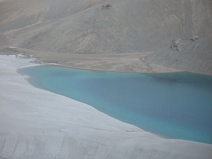 Sapphire Lake srrounded by breccia deposits |
 QuickTime video: we arrive by helicopter at Sapphire lake |
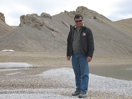
 Matt Reyes standing by our helicopter on the shore of Sapphire Lake |
 Leroy Chiao standing on breccia deposits that comprise the shore of Sapphire Lake |
 Matt Reyes holds a shattercone – a rock which contains fractures that resulted directly from the impact event that formed Haughton Crater 39 million years ago |
 QuickTime video: the only plant I saw near Sapphire Lake |
 QuickTime VR: panorama of Sapphire Lake |
 QuickTime video: we take off by Helicopter from Sapphire Lake and head north |
 Typical example of the terrain we flew over |
 QuickTime VR: panorama of Thomas Paine Canyon |
 Our helicpoter and pilot on the rim of Thomas Paine Canyon |
 (L to R) Matt Reyes, Keith Cowing, and Leroy Chiao standing on the rim of Thomas Paine Canyon |
 (L to R) Matt Reyes, Keith Cowing, and Leroy Chiao standing on the rim of Thomas Paine Canyon |
 HMP Principal Investigator Pascal Lee and Astronaut Leroy Chiao standing on the rim of Thomas Paine Canyon |
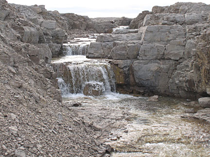 Small waterfall just above the rim of Thomas Paine Canyon |
 Jarloo Kiguktak holds a small fossil crinoid he found |
 Keith Cowing standing on the rim of Astronaut Canyon |
 Joseph Atchealak and Keith Cowing inside the helicopter |
 Pascal Lee and Leroy Chiao have a conversation next to Astronaut Canyon |
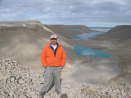
 The magnificent vista of Astronaut Canyon |
You cannot take a bad picture on Devon Island. This place is one stunning photo opportunity after another. Mostly it has to do with the landscape. Every once in a while, it has to do with humans juxtaposed against the landscape. And then in some special instances, the landscape is so evocative it simply jumps into your camera and takes the picture for you.
The regions of Devon Island where we visit to do research tend to be free (more or less) of snow during the brief summer season. Other parts of the island have permanent ice caps or some areas of vegetation. But HMP researchers tend to focus on the places where the island’s geology can be directly accessed – and of course Haughton Crater and the immediate vicinity is one – but not the only – prime places people focus on.
When I fly over this landscape one thing never ceases to pop up in my mind: the sheer vastness of this expanse. There is mile after mile, kilometer after kilometer, of space where no one lives. And while there is life here, it is mostly small things with occasional large animals. That said, the land is far from being “empty”, Quite the opposite – it is filled with vistas, geology, hydrology, and history – at every glance, in every camera frame, at every resting place.
While we now visit this place in Twin Otters, fly high overhead in intercontinental jets, and above the skies in spacecraft, we are not the first. Nor are the Inuit. Others came before them. But despite the thousands of years that humans have wandered across this island, for the vast percentage of time it has been here, not one sentient being has inhabited this place.
Also, while this place is barren, extreme, often hostile, it was not always so. At one time, after glaciations swept across the Earth, vast portions of North America looked just like this – surface scraped by improbably thick ice sheets down to rock layers of vast antiquity, Elsewhere, life rebounded to its former abundance. Here the return has been more limited. But there was a time, when Earth was warmer, when this entire region was covered with lush forests and wildlife.
It was during such a time 39 million years ago when the mile-wide impactor slammed into Devon Island. As you fly over the impact crater you can get some idea – only a portion that is, of the titanic energies that were unleashed in an instant. The basic crater feature itself was formed within seconds. Rocks on the surface were vaporized, pulverized, and strewn about. Rocks from deep within Earth – from depths of a mile or more were brought to he surface as well.
In many places, objects called “shatter cones” can be found littering the ground. Radiating fractures can be seen on these rocks that represent the effect that shockwaves had on the rock that comprised the impact site – almost as if these rocks were themselves a photograph of that violent instant in time.
On my previous two trips to Devon Island, my travels had been limited to only a small portion of the island. While much of the island is Crown land i.e. property of the Canadian government, much of the island – and much of Haughton Cater – is in Inuit Owned Land (IOL). To gain access to IOL you need to get formal permission from the Inuit people and their government. This access is highly prized and handed out with strict limits as to the number of people who can enter these regions and how they must be accompanied by Inuit representatives.
Today Leroy, Matt, and I were accorded a special privilege – to accompany Haughton-Mars Project Principal Investigator Pascal Lee on a recon trip to scout out locations for future traverses. Along with us were Jarloo Kiguktak, the mayor of the hamlet of Grise Fiord, the northernmost civilian settlement in North America and an advisor to the HMP’s 2007 field season, and his ever-fascinated son Joseph Atchealak.
Our pilot was an old hand at flying the crater and the arctic, having towed magnetic sensors and other gear back and forth over the years. We wasted no time getting airborne and on our way.
The first place we visited was Sapphire Lake.
One thing you notice as you head north and approach the Canadian high arctic by plane is that the steady loss of green in the landscape allows certain spectral features that bodies of water can exhibit to rise to prominence. I always think of John Lithgow’s line in the film “2010: The Year We Make Conact” wherein he says, “I miss green” as he sits within a grey and white spacecraft heading for Jupiter. Its true – you miss it – but its absence lets you see other colors and hues that you might otherwise miss.
As we approached Sapphire Lake we crossed large breccia deposits (shattered rock from the impact) cut by ravines and small rivers. Just as my eyes had gotten used to the hues of grey, brown, and yellow (and no green) a glitter of blue – followed by a blast of sapphire emerged as an apparition on the landscape. As we got closer I could see that its spectral nature was pure and untouched. The iridescent blue color is a function of the water and the limestone material at its bottom.
As we swooped in for our first touchdown the magical nature of what we were doing reached a crescendo. We all exited the plane and began to explore. While the others climbed a hill of breccia fragments I lingered behind to shoot some panoramas and drink in the place. With the exception of my friend’s voices up the hill, and a wisp of wind, there was a silence of the sort you can rarely experience.
There was no life to be seen – although there was probably a small population of arctic char in the lake. As we descended I noticed a lone plant and stopped to shoot a short piece of video of it waving in the simple breeze.
Then it was back into the helo for another jump across the island. As we flew north the terrain became more incised with valleys. Then it became smooth with vast plains of yellow and brown hues – all interlaced with the polygonal shapes one often sees here – a function of the action of subsurface ice upon material on the surface.
Another turn and we headed due north. As we did the canyons became deeper and more pronounced. They also started to look very Mars-like. Indeed, add a red/orange filter and this could easily be a side canyon of Vallis Marineris.
After a few more minutes of flying and we began to descend directly for the rim of a canyon. With deft skill, our pilot dropped us 30 feet or so from the edge. What a sight. We suddenly found ourselves poised on the lip of Thomas Paine Canyon with a vista any Martian would be familiar with – again minus the redness.
As we began to walk around the rim, we crossed a small stream with a waterfall just phill from us. As we wound around the canyon rim we saw a spectacular polar waterfall hurling itself off of the edge of the canyon so as to splash on rocks 500 feet or so below. To the northeast you could see that the canyon emptied to the sea.
The rocks, the vista, the grandeur were of the sort you’d expect to see in a painting by 19th century landscape artists such as Thomas Moran, Albert Bierstadt, or Frederic Church. It was impossibly big and hauntingly spectacular.
I have been to the Grand Canyon, toured Bryce canyon, visited and climbed in Yosemite – but this place takes you a place beyond – since so few people have ever seen it. Again, while the Inuit and their ancestors have been wandering across these places for thousands of years, they have not managed to tread everywhere. As such, when you walk around places like this – and touch the stones, you have an excellent chance of being the first human to do so. It’s hard to say that these days on our ever-shrinking planet.
Leroy, Matt and I were just blown away by the place. Since none of us had any real phobia of heights, so we were all as close as common sense – and safety – would let us get to the edge. I wouldn’t say that this was a primeval landscape – that implies that something would come later. Rather, I would say that this is a mature landscape – the sort of thing a planet produces after several billion years of practice.
As we headed back to the helo Jarloo picked up a fossil – a small crinoid fragment attached to a larger piece of rock. I asked him if he had many things like this. He laughed said that his big shelf at home was already full.
Next in line was a stop at Astronaut Canyon. With the two previous stops being as spectacular as they were, Pascal told me that this would be the most spectacular of them all. As we headed to the helo I asked the pilot if there was any chance that we could dive into the canyon as we took off – just to get a nice look. He smiled and said that this has “been known to happen”.
We boarded the helo and began to rev up. Leroy was in the front left seat. With only a moment’s pause to gain a few feet of altitude we dove down into the canyon. AS we did you could tell that our pilot wore his helicopter – not just piloted it. We felt like birds. What a thrill – and what a sight – you could see the strata that represented the island’s past whooshing by.
We climbed back out of the canyon and headed north. This time the terrain remained riddled with canyons and incised terrain. Within a few minutes we approached a spectacular sight – the largest canyons yet – broad and wide, with fingers from the sea at their bottom, filled with large chunks of ice, and Thomas Lee inlet in the distance.
We landed at the highest point overlooking the view. If the previous vistas were stunning, this one was a quantum leap beyond. We were looking out across Astronaut Canyon – with an astronaut in our midst. We were there for perhaps 15 to 20 minutes.
On one hand, this was not nearly the time such a place should command. Landscape painters would have spent days in such a locale. Yet on the other hand its magnificence seared itself into my mind with a permanence that I won’t shake any time soon.
As we sat and reflected on the scene, Leroy, Pascal and I talked about Mars. At one point I said “anyone with the sheer audacity to even contemplate sending humans to another world such as Mars should be required to spend long stays in a place like this”.
The immensity of visiting another world – not just for stunts – but also to come to know the world – is not something you can plan for using PowerPoint presentations – which is how NASA often likes to do things.
You need to have a visceral, personal understanding of the scope of such an undertaking before you start to do it. Having taken some personal risk to visit such a place – and then live there – is a good way to start.
Even with a helicopter and a fleet of ATVs we’d all be hard pressed to say that we truly understood Devon Island if we just showed up one day with only satellite images to go by. If we hope to explore Mars personally – we need to go there – to stay – for prolonged periods of time. And is so doing, we need to make damn sure that we have tested our mettle in places such as this before we dare try to put our feet on Mars.
While you can test your hardware and software out in parking lots outside your lab building, you cannot fully test the hardware for its ultimate purpose until you have taken it to a place where the spare parts are what you brought with you.
Moreover, the solutions you come up with when a very real, hostile environment presents you with surprises are far different than what you might come up with if you knew that you could hop in your car at 3:30 pm and drive home or dinner. These solutions, how you arrived at them, and how the lessons they teach you are incorporated in improvements are what will better equip us for Mars.
Our little chat completed, we needed to hop back on the helo and get back to Base Camp to greet an incoming Twin Otter flight.
As we revved up again Matt was in the front left seat. True to form we dove into this canyon like any self-respecting eagle might do. We swooped through the canyon and out and up over the surrounding terrain and headed due west. Matt was clearly digging the ride – and got some HD footage that will make your jaw drop.
If places on Earth can still hold such overpowering grandeur – and manage to do so on a planet we call ‘home’ – I can only imagine what the first human inhabitants will face when they have a world with the same surface area as Earth’s dry surface to explore.
Boggles the mind.
About Devon Island, The Haughton-Mars Project, and the Mars Institute
The Haughton-Mars Project (HMP) is an international interdisciplinary field research project centered on the scientific study of the Haughton impact structure and surrounding terrain, Devon Island, high arctic, viewed as a terrestrial analog for Mars. The rocky polar desert setting, geologic features and biological attributes of the site offer unique insights into the possible evolution of Mars – in particular the history of water and of past climates on Mars, the effects of impacts on Earth and on other planets, and the possibilities and limits of life in extreme environments. In parallel with its science program, the HMP supports an exploration program aimed at developing new technologies, strategies, humans factors experience, and field-based operational know-how key to planning the future exploration of the Moon, Mars and other planets by robots and humans. The HMP managed jointly by the Mars Instituteand by the SETI Institute.
Keith Cowing’s 2007 Devon Island Journals
10 July 2007: Back to the Arctic
11 July 2007: Heading North
12 July 2007: Dropping Onto Devon Island
13 July 2007: Teaching About Roses on Mars
14 July 2007: Using an iPhone on Mars
15 July 2007: Surreal Landscapes and Late Evening Thoughts
16-17 July 2007: Webcasts, Robots, Astronauts, and Dogs
18 July 2007: Ancient Memorials for Modern Space Explorers
19 July 2007: Sheer Audacity
20-22 July 2007: The Persistence of Memory
27 July 2007: Polar Deserts and Global TV
Keith Cowing’s 2003 Devon Island Journals
17 Jun 2003: Preface: Moving from Green to Grey
3 Jul 2003: Waiting in Resolute
3-5 July 2003: Arrival and Getting to Work
6 July 2003: Getting in the Groove
7 July 2003: Part 1: Being here – and being there.
7 July 2003: Part 2: Getting Out of Base Camp
8 July 2003: Infrastructure
9 July 2003: Re-connected; Planting Seeds
17 July 2003: Rover Arrival
18 July 2003: Wind
19 July 2003: Illness, Good Food, and Morale
20 July 2003: Arctic Memorials and Starship Yearnings
20 July 2003: Going Home
21 July 2003: Departure – and One Last Dedication
24 July 2003: 24 July 2003: Homeward Bound – In Slow Motion
26 August 2003: Home +30
Keith Cowing’s 2002 Devon Island Journals
8 Jul 2002: Arrival
9 Jul 2002: Getting acquainted – and down to work
10 Jul 2002: Mars carpentry
11 Jul 2002: Lexan Kites, shotguns, and Driver’s Ed
12 Jul 2002: Building and exploring
13-15 Jul 2002: Building a Mars greenhouse on Earth
16 Jul 2002: Sealing Greenhouses on Earth – and Mars; 6 Wheeled Rovers
17 Jul 2002: Greenhouse Dedication, Fishing, and Mystery Food
18 Jul 2002: Giving Blood, Eternal Light, and an Evening Commute
19 Jul 2002: The Hottest Place on Devon Island, T-shirts, a Star Trek hello
20 Jul 2002: Mars Airplanes and Communicating With Earth
21 Jul 2002: Visiting ministers, missing ‘green’, and crater tours
22 Jul 2002: The hottest place on Devon Island
23 Jul 2002: Farewells, Birthdays, and Bartering
24 Jul 2002: EVAs, movies – and ‘being here’
25 Jul 2002: Russian TV, webcam privacy, and being on Mars for a few minutes
26 Jul 2002: Cold Feet, Chocolate, and Home Cooking
27 Jul 2002: Anchors and anemometers
28 Jul 2002: Drilling into permafrost; leaving footprints for eternity
29 Jul 2002: Showering near the North Pole; one last look around
30 Jul 2002: Departure and arrival
31 Jul 2002: Culture shock and flight delays
1 Aug 2002: Departure into darkness
2 Aug 2002: Green overdose; home at last
2 Sep 2002: Home +30


