ISS Photo: Big Thompson Mesa
high res (1.2 M) low res (85 K)
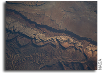
ISS020-E-009861 (14 June 2009) — Big Thompson Mesa in the Capitol Reef National Park, Utah is featured in this image photographed by an Expedition 20 crew member on the International Space Station. This detailed photograph depicts a portion of Big Thompson Mesa located near the southern end of Capitol Reef National Park.
Capitol Reef National Park is located on the Colorado Plateau, a physiographic and geologic province that comprises the adjacent quarters of Arizona, Colorado, New Mexico and Utah. Big Thompson Mesa (upper right) is part of a large feature known as the Waterpocket Fold. The Fold is a geologic structure called a monocline, characterized by generally flat-laying sedimentary rock layers with a steep and highly localized flexure– much like a carpet runner draped over a stair step. Monoclines on the Colorado Plateau are thought to be the result of faulting of stratigraphically lower and more brittle crystalline rocks; while the crystalline rocks were broken into raised or lowered blocks, the overlaying, less brittle sedimentary rocks were flexed without breaking.
According to scientists, the portion of the Waterpocket Fold illustrated in this image includes layered rocks formed during the Mesozoic Era (approximately 250 — 65 million years ago) — the oldest layers are at the bottom of the sequence (and also, in this view, the image), with each successive layer younger than the preceding one going upwards in the sequence. Not all of the units present are clearly visible, but some of the major units can be easily distinguished.
The bottom half of the image includes the oldest rocks in the view: dark brown and dark green Moenkopi (Trm) and Chinle (Trc) Formations. At center, two strikingly colored units are visible — light red to orange Wingate Sandstone (Jw) and white Navajo Sandstone (Jn). A topographic bench above these units includes reddish brown to brown Carmel Formation (Jc) and Entrada Sandstone (Je). The top of the cliff face above this bench – Big Thompson Mesa – is comprised of brown Dakota Sandstone (Kd). Scientists believe this sequence represents more than 100 million years of deposition. Much younger Quaternary (2.0 million to approximately 10,000 years old) deposits are also present in the view. A regional view of Capitol Reef National Park and the Waterpocket Fold is available here. The area shown in this view is located approximately 65 kilometers to the southeast of Fruita, UT near the southern end of Capitol Reef National Park.


