GOES-13 sees an extraordinarily early Atlantic low in the tropics
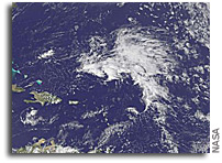
IMAGE: This visible image of the early tropical low several hundred miles north-northeast of Puerto Rico was captured on April 20 at 17:45 UTC (1:45 p.m. EDT) from the GOES-13 satellite.
Hurricane season doesn’t start in the Northern Atlantic Ocean until June 1, but a low pressure system in doesn’t seem to want to follow the calendar. There’s a low pressure area with a small chance for development north-northeast of Puerto Rico, and the GOES-13 satellite captured a visible image of the storm.
The National Hurricane Center (NHC) issued a Special Tropical Weather Outlook today, April 20, that noted the low pressure area was located about 460 miles northeast of San Juan, Puerto Rico at 3:35 p.m. EDT. The NHC noted that slow development is possible over next couple of days. The low is moving west -northwest at 10mph.
The image was created using satellite imagery was captured on April 20 at 17:45 UTC (1:45 p.m. EDT) from the Geostationary Operational Environmental Satellite (GOES-13). Although it is not easy to pick out the center of circulation in the image, it is located to the west of the largest area of clouds.
GOES satellites are operated by the National Oceanic and Atmospheric Administration. The image was created by NASA’s GOES Project, located at NASA’s Goddard Space Flight Center, Greenbelt, Md.
The NHC gives this low a 20 percent chance of development into a sub-tropical or tropical storm over the next two days before it hits wind shear, which will weaken it.


