
Plan for global Earth monitoring agreed at Tokyo summit
Representatives from 47 countries and more than two dozen international
organisations met in Tokyo last week, coming a significant step closer to
achieving the goal of an integrated Earth monitoring network.
The Japanese capital was the location of the fourth Group on Earth Observations
(GEO) summit. GEO is an intergovernmental working group charged with developing
a plan for a co-ordinated global Earth Observation network providing data on
environmental factors for both scientific and humanitarian purposes.
GEO was created during last July’s Earth Observation Summit in Washington DC and
was made responsible for producing a ten-year programme to co-ordinate space and
ground based global monitoring systems, to be known as the Global Earth
Observation System of Systems (GEOSS).
ESA and the European Union’s Global Monitoring for Environment and Security
(GMES) joint initiative serves as Europe’s contribution to the worldwide GEOSS
effort.
The 22-23 April Tokyo summit — the fourth such meeting and known as GEO-4 — is
the successor to previous gatherings last year in Baverno, Italy and Cape Town,
South Africa. The work done at GEO-4 saw the finalisation of a draft
implementation plan, which was then approved by ministers gathering at the
one-day Earth Observation Summit II immediately following GEO-4 on Sunday 25 April.
"Securing the draft implementation plan represents a useful step forward in
turning the GEOSS idea into a reality," remarked ESA Earth Observation Director
of Programmes Jos?© Achache. "And all participants from Europe were united in
their support of GMES as its European component."
The aim behind GEOSS is to maximise the effectiveness of Earth Observation by
minimising data gaps, building capacity and exchanging information as fully and
quickly as possible.
Developed and developing nations alike will have access to all data gathered by
the network, following the model of the World Meteorological Organisation’s
four-decade-old World Weather Watch, which co-ordinates the globe’s weather
satellites along with in-situ climate stations.
The increased knowledge of the environment that a similar global Earth
Observation system would provide has the potential to be an invaluable resource
for global decision makers.
"The feeling is that the summit has made an important contribution," Achache
added. "It’s about more than only improving weather forecasting and the study of
climate change. GEOSS will be a tool for planetary management, a resource for
more efficient development and a means of mitigating disasters."
This draft implementation plan will form the basis of additional work to be
carried out by five separate GEO Subgroups dealing with the subjects of
Architecture, Capacity Building, Data Utilisation, User Requirements and
International Cooperation. ESA is a Co-Chair of the Architecture Sub-Group and
also a member of the GEO Secretariat.
The finalised ten-year GEOSS implementation plan will be presented for
acceptance to ministers at the Earth Observation Summit III, scheduled to take
place in Brussels in February of next year.
Related links
* Group on Earth Observations
http://earthobservations.org/default.asp
* GMES
http://earth.esa.int/gmes/
IMAGE CAPTIONS:
[Image 1:
http://www.esa.int/esaSA/SEMTR077ESD_earth_1.html]
Prime Minister Junichiro Koizumi delivers his speech during the Earth
Observation Summit II in Tokyo, Sunday, April 25, 2004. Officials from 47
nations and more than dozen international organizations are meeting here to
decide what the Earth Observation ‘system of systems’ should look like, who will
run it and how open it should be. "The international community has to accurately
evaluate what is happening around the globe before we can take appropriate
steps," he told delegates.
Credits: AP Photo/Itsuo Inouye
[Image 2:
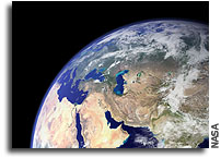
http://www.esa.int/esaSA/SEMTR077ESD_earth_1.html#subhead1]
Meteosat-4 artificially-coloured visible channel full-disc Earth image, 6 July
1991. Developed by ESA and since 1995 operated by Eumetsat, Meteosat has been
routinely returning Earth imagery from geostationary orbit since 1977. (Credit:
ESA/Eumetsat)
Credits: ESA/Eumetsat
[Image 3:
http://www.esa.int/esaSA/SEMTR077ESD_earth_1.html#subhead2]
Jos?© Achache is the new ESA Director of Earth Observation, appointed by the ESA
Council of 19/20 December 2001
Credits: CNES/Eric MARTIN , 2002
[Image 4:
http://www.esa.int/esaSA/SEMTR077ESD_earth_1.html#subhead4]
More than 150 ERS images acquired between 1992 and 2000 were combined by the
British Geological Survey to produce this InSAR-based depiction of crustal
movement around Hamamatsu-Yaizu on Japan’s south coast. It measures the annual
average line of sight velocity in millimetres per year of ‘permanent scatterer’
fixed points. Light blue indicates 1 to 3 mm, green 1 to -1 mm, yellow -1 to -3
mm, orange -3 to -5 mm, and red greater than -5 mm. Applications of the data
include geological risk assessment for the insurance industry and exploring
links between ground movement and gas pipe failure.


