Destructive Northern California Fires Viewed From Space
The major fires burning in Northern California’s wine country continue to burn relentlessly, forcing additional mass evacuations.
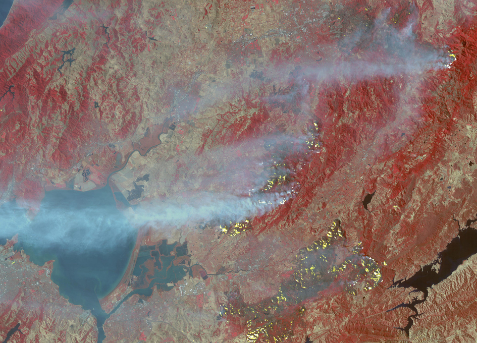
The Advanced Spaceborne Thermal Emission and Reflection Radiometer (ASTER) instrument on NASA’s Terra satellite acquired this image the morning of Oct. 12, 2017. The fires have consumed hundreds of thousands of acres, resulting in significant loss of life, injuries and heavy property losses. The city of Santa Rosa is in the upper left corner; Napa is in the upper right; and Sonoma is in the center. In the image, vegetation is depicted in red and smoke is blue-gray. Active fires and hotspots, detected on ASTER’s thermal infrared channels, are in yellow. The background colors have been subdued to make the yellow hotspots more apparent. The image covers an area of 35 by 57 miles (57 by 91 kilometers) and is located near 38.3 degrees north, 122.5 degrees west.
With its 14 spectral bands from the visible to the thermal infrared wavelength region and its high spatial resolution of 15 to 90 meters (about 50 to 300 feet), ASTER images Earth to map and monitor the changing surface of our planet. ASTER is one of five Earth-observing instruments launched Dec. 18, 1999, on Terra. The instrument was built by Japan’s Ministry of Economy, Trade and Industry. A joint U.S./Japan science team is responsible for validation and calibration of the instrument and data products.
The broad spectral coverage and high spectral resolution of ASTER provides scientists in numerous disciplines with critical information for surface mapping and monitoring of dynamic conditions and temporal change. Example applications are: monitoring glacial advances and retreats; monitoring potentially active volcanoes; identifying crop stress; determining cloud morphology and physical properties; wetlands evaluation; thermal pollution monitoring; coral reef degradation; surface temperature mapping of soils and geology; and measuring surface heat balance.
The U.S. science team is located at NASA’s Jet Propulsion Laboratory, Pasadena, Calif. The Terra mission is part of NASA’s Science Mission Directorate, Washington, D.C.
More information about ASTER is available at asterweb.jpl.nasa.gov/.
Image credit: NASA/METI/AIST/Japan Space Systems, and U.S./Japan ASTER Science Team


