Mars Odyssey THEMIS Image: Pavonis Mars Summit Caldera
 |
|
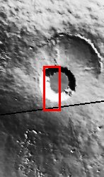
| This image shows part of the summit caldera of Pavonis Mons. Pavonis is the middle of three Tharsis volcanos that form a line southeast of Olympus Mons and northwest of Vallis Marineris. On Earth volcanic calderas usually form when a massive eruption has emptied out the magma chamber and the “roof” of the chamber collapses into the resultant space. It is likely that summit calderas on Martian volcanoes form in a similar manner. [Questions? Email images@themis.asu.edu] [Source: ASU THEMIS Science Team] |
NASA’s Jet Propulsion Laboratory manages the 2001 Mars Odyssey mission for NASA’s Office of Space Science, Washington, D.C. The Thermal Emission Imaging System (THEMIS) was developed by Arizona State University, Tempe, in collaboration with Raytheon Santa Barbara Remote Sensing. The THEMIS investigation is led by Dr. Philip Christensen at Arizona State University. Lockheed Martin Astronautics, Denver, is the prime contractor for the Odyssey project, and developed and built the orbiter. Mission operations are conducted jointly from Lockheed Martin and from JPL, a division of the California Institute of Technology in Pasadena.
Image Credit: NASA/JPL/Arizona State University
| Parameter | Value | Parameter | Value | |
|---|---|---|---|---|
| Latitude | 0.5 |   | Instrument | VIS |
| Longitude | 246.8E (113.2W) |   | Resolution (m) | 19 |
| Image Size (pixels) | 3043×1240 |   | Image Size (km) | 57.8×23.6 |


