Mars Odyssey THEMIS Image: Cydonia Landscape
TABLE BORDER=0 WIDTH=”100%”>

| Image Context: |
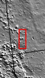 |
| Context image credit: NASA/Mars Orbiter Laser Altimeter (MOLA) Team |
| [ Find on map: Javascript version ] |
| [ Find on map: CGI version ] |
| The Cydonia region on Mars straddles the boundary between the bright, dusty, cratered highlands to the southeast and the dark, relatively dust-free, lowland plains to the west. The countless mesas and buttes that cover the region are testament to the former presence of vast layers of material that have been stripped back over the eons leaving the isolated remnants seen in this THEMIS image. Evidence of larger masses of these remnants is visible to the south in the MOLA context image. Note the lobes of ejecta emanating from the large crater in the upper right of the THEMIS image. This style of ejecta is thought to arise when an impact occurs into water or ice-rich material, indicating that at least at the time of the impact such material was present. [Questions? Email images@themis.asu.edu] [Source: ASU THEMIS Science Team] |
NASA’s Jet Propulsion Laboratory manages the 2001 Mars Odyssey mission for NASA’s Office of Space Science, Washington, D.C. The Thermal Emission Imaging System (THEMIS) was developed by Arizona State University, Tempe, in collaboration with Raytheon Santa Barbara Remote Sensing. The THEMIS investigation is led by Dr. Philip Christensen at Arizona State University. Lockheed Martin Astronautics, Denver, is the prime contractor for the Odyssey project, and developed and built the orbiter. Mission operations are conducted jointly from Lockheed Martin and from JPL, a division of the California Institute of Technology in Pasadena.
Image Credit: NASA/JPL/Arizona State University
| Parameter | Value | Parameter | Value | |
|---|---|---|---|---|
| Latitude | 40.7 |   | Instrument | VIS |
| Longitude | 350.8E (9.2W) |   | Resolution (m) | 19 |
| Image Size (pixels) | 3007×1181 |   | Image Size (km) | 57.1×22.4 |


