Mars Odyssey THEMIS Image: Geological Time on Display in Arabia Terra
 |
|
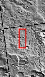
| This scene from the dust covered plains of eastern Arabia Terra portrays a range of geological time. Three craters at the center of the image capture some of this range. Two have the classic bowl-shape of small, relatively recent craters while the one just to the north has seen much more history. Its rim has been scoured away by erosion and its floor has been filled in by material likely of a sedimentary nature. The channels that wind through the scene may be the oldest features present while the relatively dark streaks scattered about could have been produced in the past few years or even months as winds remove a layer of dust to reveal darker material below. [Questions? Email images@themis.asu.edu] [Source: ASU THEMIS Science Team] |
NASA’s Jet Propulsion Laboratory manages the 2001 Mars Odyssey mission for NASA’s Office of Space Science, Washington, D.C. The Thermal Emission Imaging System (THEMIS) was developed by Arizona State University, Tempe, in collaboration with Raytheon Santa Barbara Remote Sensing. The THEMIS investigation is led by Dr. Philip Christensen at Arizona State University. Lockheed Martin Astronautics, Denver, is the prime contractor for the Odyssey project, and developed and built the orbiter. Mission operations are conducted jointly from Lockheed Martin and from JPL, a division of the California Institute of Technology in Pasadena.
Image Credit: NASA/JPL/Arizona State University
| Parameter | Value | Parameter | Value | |
|---|---|---|---|---|
| Latitude | 9.4 |   | Instrument | VIS |
| Longitude | 45.9E (314.1W) |   | Resolution (m) | 19 |
| Image Size (pixels) | 3025×1237 |   | Image Size (km) | 57.5×23.5 |


