 |
| Image Context: |
 | | Context image credit: NASA/Mars Orbiter Laser Altimeter (MOLA) Team | [ Find on map: Javascript version ]
| | [ Find on map: CGI version ] |
|
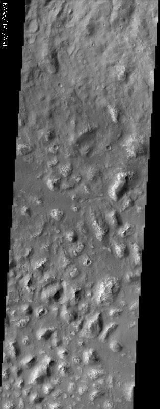
Among the many varied landscapes on Mars the term chaos is applied to those places that have a jumbled, blocky appearance. Most of the better known chaotic terrain occurs in the northern hemisphere but there are other occurrences in the southern hemisphere, three of which are centered on ~180 degrees west longitude. Ariadnes Colles, Atlantis, and Gorgonum Chaos all share similar features: relatively bright, irregularly shaped knobs and mesas that rise above a dark, sand-covered, hummocky floor. Close inspection of this THEMIS image shows that the darker material tends to lap up to the base of the knobs and stops where the slopes are steep. On some of the lowest knobs, the dark material appears to overtop them. The knobs themselves are highly eroded, many having a pitted appearance. Images from the camera on Mars Global Surveyor clearly show that the dark material is sand, based on its mantling appearance and the presence of dunes. It looks as though the material that composes the knobs was probably a continuous layer that was subsequently heavily eroded. While it is likely that the dark sand is responsible for some of the erosion it is also possible that the this landscape was eroded by some other process and the sand was emplaced at a later time.
[Source: ASU THEMIS Science Team] |
|
|
Note: this THEMIS visual image has not been radiometrically nor geometrically calibrated for this preliminary release. An empirical correction has been performed to remove instrumental effects. A linear shift has been applied in the cross-track and down-track direction to approximate spacecraft and planetary motion. Fully calibrated and geometrically projected images will be released through the Planetary Data System in accordance with Project policies at a later time.
NASA’s Jet Propulsion Laboratory manages the 2001 Mars Odyssey mission for NASA’s Office of Space Science, Washington, D.C. The Thermal Emission Imaging System (THEMIS) was developed by Arizona State University, Tempe, in collaboration with Raytheon Santa Barbara Remote Sensing. The THEMIS investigation is led by Dr. Philip Christensen at Arizona State University. Lockheed Martin Astronautics, Denver, is the prime contractor for the Odyssey project, and developed and built the orbiter. Mission operations are conducted jointly from Lockheed Martin and from JPL, a division of the California Institute of Technology in Pasadena.
Image Credit: NASA/JPL/Arizona State University
|
|
| [ Show Full-Size Image (GIF) ] [ Show Full-Size Image (JPG) ] |
| [ Show Full-Size Image (PNG) ] [ Show Full-Size Image (TIF) ] |
| Parameter | Value | | Parameter | Value |
|---|
| Latitude | -34.1 |
  |
Instrument | VIS |
| Longitude | 188.5W (171.5E) |
  |
Resolution (m) | 19 |
| Image Size (pixels) | 3061×1201 |
  |
Image Size (km) | 58.2×22.8 |
|


