Mars Odyssey THEMIS Image: Surface Composition Differences in Martian Canyon
 |
|
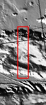
| Color differences in this daytime infrared image taken by the camera on NASA’s Mars Odyssey spacecraft represent differences in the mineral composition of the rocks, sediments and dust on the surface.
The image shows a portion of a canyon named Candor Chasma within the great Valles Marineris system of canyons, at approximately 5 degrees south latitude, 285 degrees east (75 degrees west) longitude. The area shown is approximately 30 by 175 kilometers (19 by 110 miles). The image combines exposures taken by Odyssey’s thermal emission imaging system at three different wavelengths of infrared light: 6.3 microns, 7.4 microns and 8.7 microns. [Source: ASU THEMIS Science Team] |
NASA’s Jet Propulsion Laboratory manages the 2001 Mars Odyssey mission for NASA’s Office of Space Science, Washington, D.C. The Thermal Emission Imaging System (THEMIS) was developed by Arizona State University, Tempe, in collaboration with Raytheon Santa Barbara Remote Sensing. The THEMIS investigation is led by Dr. Philip Christensen at Arizona State University. Lockheed Martin Astronautics, Denver, is the prime contractor for the Odyssey project, and developed and built the orbiter. Mission operations are conducted jointly from Lockheed Martin and from JPL, a division of the California Institute of Technology in Pasadena.
Image Credit: NASA/JPL/Arizona State University
| Parameter | Value | Parameter | Value | |
|---|---|---|---|---|
| Latitude | -5 |   | Instrument | IR |
| Longitude | 75W (285E) |   | Resolution (m) | 100 |
| Image Size (pixels) | 1751×289 |   | Image Size (km) | 175.1×28.9 |


