NASA MODIS Image of the Day: July 4, 2008 – Dust Storm over the Persian Gulf
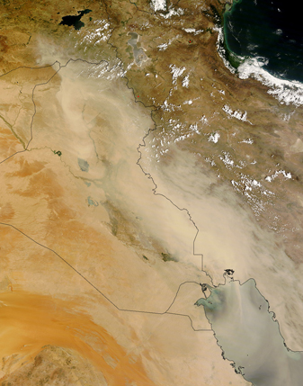
A dust storm over the Persian Gulf continued for a second day on July 2, 2008, as the MODIS on NASA’s Terra satellite flew overhead.
The dust appears to have originated in northern Iraq, although specific source points for the storm are not visible in this image.
A plume of dust curls over the borders between Iraq (left center edge), Syria (just above Iraq), and Turkey (just above Syria), but the thickest dust hovers over the border between Iraq and Iran. Arising from fine sediments of the Tigris and Euphrates floodplain, the dust blows toward the southeast. Around the dust storm, skies appear largely clear. Dust obscures the view of the Persian Gulf and Iraq’s Buhayra-ath Tharthar. To the north, however, the nearly black water of the Caspian Sea and Turkey’s Van Golu appear clearly through dust-free skies. The pale hues of Daryacheh-ye Orumiyeh likely result not from dust but from a combination of the salt lake’s shallow depth and sunglint, the reflection of sunlight on the water’s surface.


