NASA MODIS Image of the Day: June 22, 2007 – California and Nevada
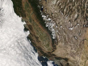
This image of California and Nevada was acquired by the MODIS on the Terra satellite on May 31, 2007.
Clouds over the Pacific Ocean crowd close to the California coast.
The cloud patterns are caused by cool Pacific ocean waters, which tends to cool the air and produce low, stable clouds. Once the air moves onshore, it quickly heats up and dissipates the clouds, and the uplift from the Sierra Nevada wrings out any moisture that is left in the air. West of the Pacific are: the relatively low coastal ranges that run near the California coast line, the San Joaquin valley which grows a great deal of fruits and produce eaten in the US, the heavily forested Sierra Nevada mountain range, and the arid Nevada deserts. The black lines are the state borders. You can spot Los Angeles towards the bottom of the California coastline, visible as a patch of gray, Death Valley (south end and east of the Sierra Nevada mountains), and Lake Tahoe (on the California/Nevada border). The few red dots are active fires in the region.


