NASA MODIS Image of the Day: February 12, 2007 – Clouds over Ice
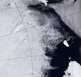
In a photo-like satellite image, clouds are often hard to distinguish when they are over things like snow or ice. For those trying to track clouds from space, to understand cloud physics, or to predict the weather, the problem is frustrating. The solution is using a combination of visible and invisible wavelengths of light, to produce a false-color image, such as this one, which is made of of red, shortwave infrared, and thermal infrared data. If you move your mouse over the image, you will see a true color (red, green, blue) image of the same scene.
In the false-color image, clouds take on a slight orange tint, while the underlying sea ice and the land-based glacial ice over Kvitoya Island become bright purple. (Kvitoya Island is the large solid pink shape towards the right center of the image.) Ocean water goes from nearly black in visible light to bright blue in infrared. In the visible image, only the high clouds that cast their shadow on the cloud and ice below them are visible, but the infrared image reveals a large yellowish bank of clouds over the ice.


