NASA MODIS Image of the Day: February 8, 2007 – Ice and Cloud Streets in the Sea of Okhotsk
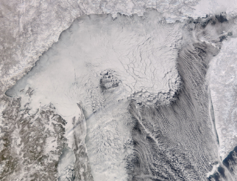
The Sea of Okhotsk is featured in this image acquired by the MODIS on the Terra satellite on February 6, 2007. The Sea of Okhotski is located between the north of Japan and the Kamchatka Peninsula, and bordered on the north by Siberia. In winter, navigation on the Sea of Okhotsk becomes difficult, or even impossible, due to the formation of large ice floes, which you can see in this image. This is partly because the large amount of freshwater from the Amur River lowers the salinity and raises the freezing point of the sea.
On the right and right bottom side of the image, there are also streamers of clouds, known as streets, off the edges of the ice. Cloud streets are rows of cumulus or cumulus-type clouds that are aligned parallel to the low-level wind. For more information about cloud streets, view this Wikipedia entry.


